IMAGES TAKEN NEAR TO
Blue Row, THIRSK, YO7 2JP
Introduction
This page details the photographs taken nearby to Blue Row, YO7 2JP by members of the Geograph project.
The Geograph project started in 2005 with the aim of publishing, organising and preserving representative images for every square kilometre of Great Britain, Ireland and the Isle of Man.

There are currently over 7.5m images from over14,400 individuals and you can help contribute to the project by visiting https://www.geograph.org.uk
Image Map (Loading...)


Getting Data...Please wait
Leaflet Map data © OpenStreetMap
Images are licensed for reuse under creativecommons.org/licenses/by-sa/2.0
Notes
- Clicking on the map will re-center to the selected point.
- The higher the marker number, the further away the image location is from the centre of the postcode.
Image Listing (63 Images Found)
Images are licensed for reuse under creativecommons.org/licenses/by-sa/2.0
Image
Details
Distance
1
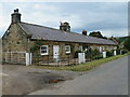
Blue Row Kepwick
A row of five single storey cottages dated around the early to mid 19th century and originally built for workers on the Kepwick estate. The whole row is Grade II listed.
Image: © Gordon Hatton
Taken: 30 Jun 2022
0.01 miles
2
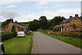
Kepwick
A very small but attractive village dominated by farms.
Image: © Bill Boaden
Taken: 31 Aug 2013
0.02 miles
4
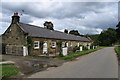
Kepwick Village 4
Five cottages known as Blue Row in Kepwick.
Image: © David Rogers
Taken: 23 Jun 2008
0.03 miles
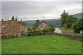
5
The eastern end of Kepwick
The village only has one street. The housing begins a few yards along from here, though there is a farm behind my right.
Image: © Bill Boaden
Taken: 31 Aug 2013
0.05 miles
6
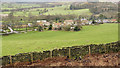
Kepwick
The small settlement at Kepwick seen over a grassed field from the bridleway at Atlay Bank.
Image: © Trevor Littlewood
Taken: 24 Dec 2011
0.05 miles
7
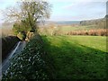
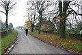
View North From Near Kepwick
Climbing up from Bridge Beck the lane just sneaks into this grid square before reaching Kepwick. I had to climb the embankment and hedge to obtain an unrestricted view. Fortunately the hedge had recently been slashed.
Image: © Mick Garratt
Taken: 11 Dec 2005
0.06 miles
9
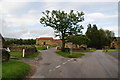
Triangle and bench at the end of Kepwick
The road to the left, which here looks like a minor road, is the only one that is a through route. The road leads to the old quarries and a sign soon tells you that it is unsuitable for motors.
Image: © Bill Boaden
Taken: 31 Aug 2013
0.07 miles
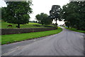
10
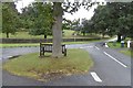
Road triangle, Kepwick
The road to the left climbs up onto the Hambleton moors.
Image: © Richard Webb
Taken: 11 Aug 2016
0.07 miles