IMAGES TAKEN NEAR TO
Low Road, THIRSK, YO7 2BY
Introduction
This page details the photographs taken nearby to Low Road, YO7 2BY by members of the Geograph project.
The Geograph project started in 2005 with the aim of publishing, organising and preserving representative images for every square kilometre of Great Britain, Ireland and the Isle of Man.

There are currently over 7.5m images from over14,400 individuals and you can help contribute to the project by visiting https://www.geograph.org.uk
Image Map (Loading...)


Getting Data...Please wait
Leaflet Map data © OpenStreetMap
Images are licensed for reuse under creativecommons.org/licenses/by-sa/2.0
Notes
- Clicking on the map will re-center to the selected point.
- The higher the marker number, the further away the image location is from the centre of the postcode.
Image Listing (8 Images Found)
Images are licensed for reuse under creativecommons.org/licenses/by-sa/2.0
Image
Details
Distance


4

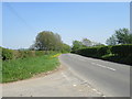
Common Lane
Narrow road heading north from Mill Dike Lane
Image: © Chris Heaton
Taken: 1 Aug 2016
0.07 miles
5
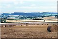
Arable fields from Spring Lane near Carlton Husthwaite
A summertime view across cornfields towards the Kilburn White Horse.
Image: © Gordon Hatton
Taken: Unknown
0.12 miles
7

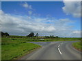
Green, yellow and white
The view north eastwards from Spring Lane towards the White Horse above Kilburn. The green of a cereal crop contrasts with the bright yellow of the rapeseed beyond. Taken from almost exactly the same place as a previous photo, but at a different time of year.
Image: © Gordon Hatton
Taken: 23 May 2010
0.18 miles
8

Bare field
Very large field bounded by Spring Lane and Croft Lane.
Image: © Christine Johnstone
Taken: 23 Sep 2010
0.25 miles