IMAGES TAKEN NEAR TO
Little Thirkleby, THIRSK, YO7 2BB
Introduction
This page details the photographs taken nearby to Little Thirkleby, YO7 2BB by members of the Geograph project.
The Geograph project started in 2005 with the aim of publishing, organising and preserving representative images for every square kilometre of Great Britain, Ireland and the Isle of Man.

There are currently over 7.5m images from over14,400 individuals and you can help contribute to the project by visiting https://www.geograph.org.uk
Image Map (Loading...)


Getting Data...Please wait
Leaflet Map data © OpenStreetMap
Images are licensed for reuse under creativecommons.org/licenses/by-sa/2.0
Notes
- Clicking on the map will re-center to the selected point.
- The higher the marker number, the further away the image location is from the centre of the postcode.
Image Listing (13 Images Found)
Images are licensed for reuse under creativecommons.org/licenses/by-sa/2.0
Image
Details
Distance
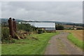
1
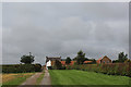
High House Farm
Farming operation and holiday cottages.
Image: © Chris Heaton
Taken: 21 Aug 2018
0.01 miles
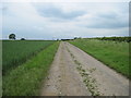
2
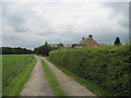
Track to High House Farm
From Thwaites Lane
Image: © Martin Dawes
Taken: 13 Jun 2012
0.02 miles
3
High House Farm
From the field footpath from Thirkleby
Image: © Martin Dawes
Taken: 13 Jun 2012
0.02 miles
4
High House Farm
At 63m it's hardly very high. But it does sit on a small hill.
Image: © Matthew Hatton
Taken: 17 Apr 2010
0.03 miles
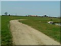
5
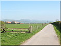
Thwaites Lane, Thirkleby.
Tarmaced farm road heading for High House Farm. Hood Hill stands behind the farm, with the near vertical scarp of Roulston Scar to the right and the Kilburn White Horse beyond.
Image: © Gordon Hatton
Taken: 15 Apr 2007
0.07 miles
6
Bridleway rounding the Perimeter of High House Farm
Image: © Chris Heaton
Taken: 21 Aug 2018
0.09 miles
7
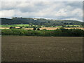
Near High House Farm
Looking towards the White Horse.
Image: © T Eyre
Taken: 15 Sep 2021
0.11 miles
8
Bridleway leading away from High House Farm
Image: © Chris Heaton
Taken: 21 Aug 2018
0.12 miles
9
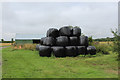
Bales and Farm Outbuilding near High House Farm
Image: © Chris Heaton
Taken: 21 Aug 2018
0.13 miles
10
Track past barn toward High House Farm
Image: © Martin Dawes
Taken: 13 Jun 2012
0.14 miles