IMAGES TAKEN NEAR TO
Osgoodby, THIRSK, YO7 2AL
Introduction
This page details the photographs taken nearby to YO7 2AL by members of the Geograph project.
The Geograph project started in 2005 with the aim of publishing, organising and preserving representative images for every square kilometre of Great Britain, Ireland and the Isle of Man.

There are currently over 7.5m images from over14,400 individuals and you can help contribute to the project by visiting https://www.geograph.org.uk
Image Map
Images are licensed for reuse under creativecommons.org/licenses/by-sa/2.0
Notes
- Clicking on the map will re-center to the selected point.
- The higher the marker number, the further away the image location is from the centre of the postcode.
Image Listing (12 Images Found)
Images are licensed for reuse under creativecommons.org/licenses/by-sa/2.0
Image
Details
Distance
1
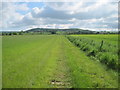
Bridleway and farm road, Low Osgoodby Grange
Looking south along the bridleway that leads past Alma House and Low Osgoodby Grange to Thirkleby.
Image: © Gordon Hatton
Taken: 12 Jun 2010
0.03 miles
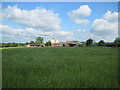
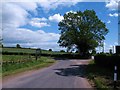
2
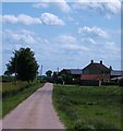
Low Osgoodby Grange
Following the bridleway northwards towards the farm at Low Osgoodby Grange
Image: © Chris Heaton
Taken: 21 Aug 2018
0.12 miles
3
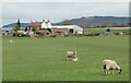
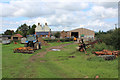
Osgoodby Grange Farm
The present farm appears to be on land once owned by Byland Abbey which had a grange [farm] here during the medieval period, whilst there is record of some of the land being transferred to Richard Askywith in 1532. To the north and east of the farm buildings there's still evidence of old ridge and furrow in the fields which could date back to medieval times.
Image: © Gordon Hatton
Taken: 5 Apr 2022
0.12 miles
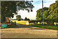
7
Drive and bridleway, Lower Osgoodby Grange
And one of many millstones to be seen on the local roadsides.
Image: © Chris
Taken: 15 Jul 2014
0.16 miles
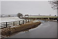
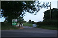
8
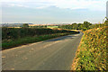
The road to Kilburn
Taken at a double bend where the road crosses the tiny Hood Beck.
Image: © Gordon Hatton
Taken: 12 Jun 2010
0.18 miles