IMAGES TAKEN NEAR TO
Saxty Way, THIRSK, YO7 1SF
Introduction
This page details the photographs taken nearby to Saxty Way, YO7 1SF by members of the Geograph project.
The Geograph project started in 2005 with the aim of publishing, organising and preserving representative images for every square kilometre of Great Britain, Ireland and the Isle of Man.

There are currently over 7.5m images from over14,400 individuals and you can help contribute to the project by visiting https://www.geograph.org.uk
Image Map
Images are licensed for reuse under creativecommons.org/licenses/by-sa/2.0
Notes
- Clicking on the map will re-center to the selected point.
- The higher the marker number, the further away the image location is from the centre of the postcode.
Image Listing (8 Images Found)
Images are licensed for reuse under creativecommons.org/licenses/by-sa/2.0
Image
Details
Distance
1
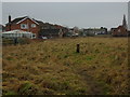
Edge of Housing Estate in Sowerby, Thirsk
Image: © Chris Heaton
Taken: 11 Jan 2018
0.08 miles
2

Green lane entering Sowerby
Coming along a footpath from Thirsk station.
Image: © DS Pugh
Taken: 15 Jun 2014
0.16 miles
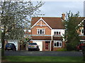
4

Green Lane West
Entering Sowerby from a footpath from Thirsk station.
Image: © DS Pugh
Taken: 15 Jun 2014
0.19 miles

6
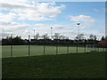
Sports pitches at Thirsk Comprehensive School
All weather pitches with floodlights.
Image: © Gordon Hatton
Taken: 10 Apr 2007
0.21 miles
7
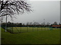
Astro Pitch at Thirsk School and Sixth Form College
Astro Pitch that serves as the home venue for Thirsk + Malton Mens Hockey Club, which field 3 sides.
Also for Thirsk Ladies Hockey Club that field an impressive 4 sides, and Northallerton Ladies Hockey Club that field 2 sides.
Image: © Chris Heaton
Taken: 11 Jan 2018
0.24 miles
8

Track to Thirsk
A green lane running into Thirsk.
Image: © DS Pugh
Taken: 15 Jun 2014
0.25 miles