IMAGES TAKEN NEAR TO
Whitelass Close, THIRSK, YO7 1FG
Introduction
This page details the photographs taken nearby to Whitelass Close, YO7 1FG by members of the Geograph project.
The Geograph project started in 2005 with the aim of publishing, organising and preserving representative images for every square kilometre of Great Britain, Ireland and the Isle of Man.

There are currently over 7.5m images from over14,400 individuals and you can help contribute to the project by visiting https://www.geograph.org.uk
Image Map (Loading...)


Getting Data...Please wait
Leaflet Map data © OpenStreetMap
Images are licensed for reuse under creativecommons.org/licenses/by-sa/2.0
Notes
- Clicking on the map will re-center to the selected point.
- The higher the marker number, the further away the image location is from the centre of the postcode.
Image Listing (24 Images Found)
Images are licensed for reuse under creativecommons.org/licenses/by-sa/2.0
Image
Details
Distance
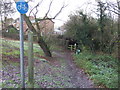
3
Old milepost on Stockton Road, Thirsk
This is the milepost that was hidden in the hedge on Stockton Road, Thirsk. For years the London mileage read 200 but when the milepost was repainted in 2008 this was changed to 221, the correct mileage. It does have a large piece missing from the top edge of the bevel. Although the names on this and the only other survivor on this route in Crathorne Image are cast, the numbers are painted on.
Image: © Hilary Jones
Taken: 25 Apr 2022
0.07 miles
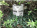
4

Old Milestone, on the A61 (was A19), Stockton Road, outside "Burniston"
Opposite Shire Road. Located on the East side of road, In hedge in front of house. Cast iron post, Thirsk casting design, erected by Thirsk & Yarm turnpike trust, 19th century.
Inscription reads: THIRSK / 1 // YARM / 19 // LONDON / 221
Grade II listed by Historic England.
Milestone Society National ID: YN_TKYA01
Image: © Christine Minto
Taken: 4 Feb 2006
0.07 miles
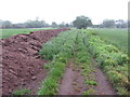
5

Old milepost on Stockton Road, Thirsk
Hidden in this hedge on Stockton Road (A61 but was A19) in Thirsk is a milepost Thirsk 1, Yarm 19, London 221.
Image: © Hilary Jones
Taken: 25 Apr 2022
0.07 miles
6
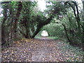
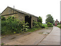
Public footpath across a field near Thirsk
Although the OS map doesn't show one at this location, a finger sign post at the track entrance declares this to be a public footpath.
Image: © Gareth James
Taken: 12 Jun 2016
0.10 miles

8
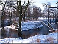
Meander on Cod Beck
The beck turns back on itself at this point north of Thirsk. Hardly the Colorado River, but interesting none the less.
Image: © Gordon Hatton
Taken: 5 Feb 2012
0.13 miles
10
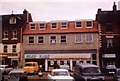
Supermarket in Thirsk Market Place
The photograph was taken when Fine Fare was still extant
Image: © Jack Hill
Taken: Unknown
0.18 miles