IMAGES TAKEN NEAR TO
High Park, YORK, YO62 7HS
Introduction
This page details the photographs taken nearby to High Park, YO62 7HS by members of the Geograph project.
The Geograph project started in 2005 with the aim of publishing, organising and preserving representative images for every square kilometre of Great Britain, Ireland and the Isle of Man.

There are currently over 7.5m images from over14,400 individuals and you can help contribute to the project by visiting https://www.geograph.org.uk
Image Map
Images are licensed for reuse under creativecommons.org/licenses/by-sa/2.0
Notes
- Clicking on the map will re-center to the selected point.
- The higher the marker number, the further away the image location is from the centre of the postcode.
Image Listing (10 Images Found)
Images are licensed for reuse under creativecommons.org/licenses/by-sa/2.0
Image
Details
Distance
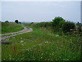
1

Track at Cockpit Hall
Looking south-eastward.
Image: © Peter Wood
Taken: 30 Jul 2014
0.05 miles
2

Farm road by Cockpit Hall
The farm road links High Park Farm to the outside world, whilst the track is also a bridleway.
Image: © Gordon Hatton
Taken: 22 Jan 2022
0.06 miles
3
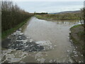
Woodhead Field Lane
A large frozen puddle at the junction of Woodhead Field Lane and Court Moor Lane.
Image: © T Eyre
Taken: 31 Jan 2021
0.07 miles
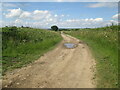
4

Obstacle at the end of Woodhead Field Lane
I may have walked this route 3 or 4 times and the 'lake' always seems to be there. Fortunately there is enough room to edge around the right hand side without having to paddle.
Image: © Gordon Hatton
Taken: 22 Jan 2022
0.07 miles
5

Track Junction with Woodhead Field Lane
Looking south-westward.
Image: © Peter Wood
Taken: 30 Jul 2014
0.10 miles
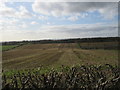
8
Court Moor Lane (track) to Woodhead Field Lane
Boundary of National Park which is to the right
Image: © Martin Dawes
Taken: 8 Jul 2021
0.17 miles
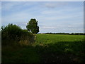
9
Court Moor Lane
Track leading to Woodhead Field Lane and stile to the right leading to footpath 514001 to Gillamoor.
Image: © Peter Holmes
Taken: 27 Jul 2008
0.22 miles
10
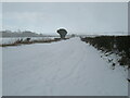
Court Moor Lane
Court Moor Lane during a heavy snow shower.
Image: © T Eyre
Taken: 10 Feb 2021
0.25 miles