IMAGES TAKEN NEAR TO
Welburn, YORK, YO62 7HH
Introduction
This page details the photographs taken nearby to Welburn, YO62 7HH by members of the Geograph project.
The Geograph project started in 2005 with the aim of publishing, organising and preserving representative images for every square kilometre of Great Britain, Ireland and the Isle of Man.

There are currently over 7.5m images from over14,400 individuals and you can help contribute to the project by visiting https://www.geograph.org.uk
Image Map
Images are licensed for reuse under creativecommons.org/licenses/by-sa/2.0
Notes
- Clicking on the map will re-center to the selected point.
- The higher the marker number, the further away the image location is from the centre of the postcode.
Image Listing (23 Images Found)
Images are licensed for reuse under creativecommons.org/licenses/by-sa/2.0
Image
Details
Distance
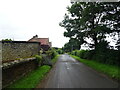
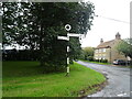
1
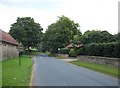
Welburn Manor Farm
View from the junction of Flatts Lane with Back Lane.
Image: © David Rogers
Taken: 18 May 2009
0.01 miles
5
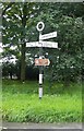
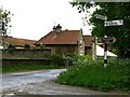
Direction Sign - Signpost by Back Lane, Wombleton
Annulus finial - 3 arms; Nichols NRYCC halo by the UC road, in parish of Wombleton (Ryedale District), Back Lane junction with Flatts Lane, by Welburn Special School, on grass verge.
Surveyed
Milestone Society National ID: YN_SE6884
Image: © Alan Rosevear
Taken: 24 Aug 2012
0.03 miles
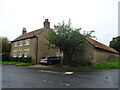
8
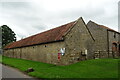
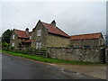
Stone barn on Back Lane, Welburn
Showing position of Postbox No. YO62 291.
See Image] for postbox.
Image: © JThomas
Taken: 4 Jul 2020
0.06 miles
9
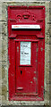
George V postbox on Back Lane, Welburn
Postbox No. YO62 291.
See Image] for context.
Image: © JThomas
Taken: 4 Jul 2020
0.07 miles