IMAGES TAKEN NEAR TO
Hutton-le-Hole, YORK, YO62 6UG
Introduction
This page details the photographs taken nearby to YO62 6UG by members of the Geograph project.
The Geograph project started in 2005 with the aim of publishing, organising and preserving representative images for every square kilometre of Great Britain, Ireland and the Isle of Man.

There are currently over 7.5m images from over14,400 individuals and you can help contribute to the project by visiting https://www.geograph.org.uk
Image Map
Images are licensed for reuse under creativecommons.org/licenses/by-sa/2.0
Notes
- Clicking on the map will re-center to the selected point.
- The higher the marker number, the further away the image location is from the centre of the postcode.
Image Listing (9 Images Found)
Images are licensed for reuse under creativecommons.org/licenses/by-sa/2.0
Image
Details
Distance
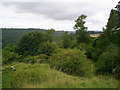
3
Douthwaite Dale
Looking down Douthwaite Dale.
Image: © T Eyre
Taken: 31 Jan 2021
0.18 miles
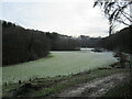
4
River Dove through Douthwaite Dale
After exiting Farndale, the Dove flows on towards Keldholme and Kirby Mills.
Some sections become subterranean during drier periods as the underlying rocks are fissured limestone.
Image: © Colin Grice
Taken: 5 Nov 2013
0.18 miles
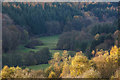
5
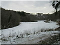
Snowy Douthwaite Dale
Looking down Douthwaite Dale at the bottom of the steep hill.
Image: © T Eyre
Taken: 28 Nov 2021
0.18 miles
6
Take the High Road
Track/Footpath junction in Rumsdale Plantation
Image: © Martin Dawes
Taken: 25 Feb 2009
0.19 miles
7
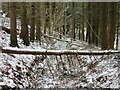
Fallen trees in Rumsdale Plantation
Three fallen trees on the path in Rumsdale Plantation after the strong winds the day before.
Image: © T Eyre
Taken: 28 Nov 2021
0.20 miles
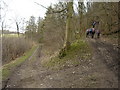
8

Bridleway heading into Douthwaite Dale
Bridleway number 50/010 dropping down into Douthwaite Dale through Rumsdale Plantation.
Image: © Gordon Hatton
Taken: 22 Jan 2022
0.23 miles
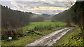
9
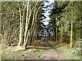
Track to Douthwaite Dale
From Back of Park's Road it descends through Rumsdale Plantation to the Shepherd's Road in Douthwaite Dale.
Image: © Martin Dawes
Taken: 25 Feb 2009
0.24 miles