IMAGES TAKEN NEAR TO
Kirkbymoorside, YORK, YO62 6HD
Introduction
This page details the photographs taken nearby to YO62 6HD by members of the Geograph project.
The Geograph project started in 2005 with the aim of publishing, organising and preserving representative images for every square kilometre of Great Britain, Ireland and the Isle of Man.

There are currently over 7.5m images from over14,400 individuals and you can help contribute to the project by visiting https://www.geograph.org.uk
Image Map
Images are licensed for reuse under creativecommons.org/licenses/by-sa/2.0
Notes
- Clicking on the map will re-center to the selected point.
- The higher the marker number, the further away the image location is from the centre of the postcode.
Image Listing (23 Images Found)
Images are licensed for reuse under creativecommons.org/licenses/by-sa/2.0
Image
Details
Distance
3
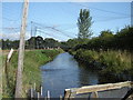
Moorland Trout Farm
On the footpath toward Welburn, water netted to protect against Heron's.
Image: © Martin Dawes
Taken: 22 Aug 2009
0.12 miles
4
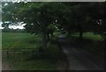
Starfitts/Starfits Lane
Leading to Starfitt Farm, the lane's name is spelled with single/double 't' on various maps and websites.
Image: © Barbara Carr
Taken: 16 Jun 2013
0.13 miles
5
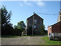
Howkeld House
On Starfits Lane near Kirkbymoorside.
Image: © David Rogers
Taken: 4 Nov 2008
0.15 miles
6
Howkeld Mill
Part of the Moorland Trout Farm, no longer a mill.
Image: © Martin Dawes
Taken: 22 Aug 2009
0.16 miles
8
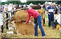
Ryedale Show 2011
A jersey cow gets a stroke of approval from a show visitor. This years show was hailed as a brilliant success, by the thousands of people who attended.
Image: © gordon clitheroe
Taken: 26 Jul 2011
0.18 miles
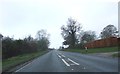
10
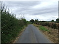
Staggered crossroads, Kirkdale
The lane running left/right, or north/south is Starfits Lane (different sources have different spelling). Straight ahead, the unclassified road joins the A170 west of Kirkbymoorside.
Image: © Pauline E
Taken: 4 Jun 2011
0.21 miles