IMAGES TAKEN NEAR TO
Oxcroft, YORK, YO62 6ER
Introduction
This page details the photographs taken nearby to Oxcroft, YO62 6ER by members of the Geograph project.
The Geograph project started in 2005 with the aim of publishing, organising and preserving representative images for every square kilometre of Great Britain, Ireland and the Isle of Man.

There are currently over 7.5m images from over14,400 individuals and you can help contribute to the project by visiting https://www.geograph.org.uk
Image Map
Images are licensed for reuse under creativecommons.org/licenses/by-sa/2.0
Notes
- Clicking on the map will re-center to the selected point.
- The higher the marker number, the further away the image location is from the centre of the postcode.
Image Listing (191 Images Found)
Images are licensed for reuse under creativecommons.org/licenses/by-sa/2.0
Image
Details
Distance
1
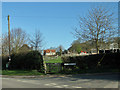
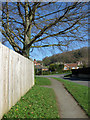
Swineherd Lane junction with Old Road
View across the play area.
Image: © Pauline E
Taken: 3 Apr 2011
0.05 miles
2
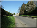
Old Road heading towards Howe End.
Junction with Swineherd Lane approaching.
Image: © Pauline E
Taken: 3 Apr 2011
0.06 miles
3
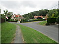
Old Road and Springfield Lane junction
Image: © Martin Dawes
Taken: 29 Jul 2021
0.06 miles
5
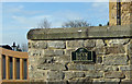
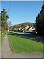
Fence on Old Road
The road swings round back towards the town centre. On the horizon is Kildare Plantation.
Image: © Pauline E
Taken: 3 Apr 2011
0.07 miles
6
Old Road, Kirkbymoorside
Kildare Plantation on the horizon.
Image: © Pauline E
Taken: 3 Apr 2011
0.08 miles
7

Old Road approaching Howe End
Marsh Lane off to the left.
Image: © Pauline E
Taken: 3 Apr 2011
0.11 miles
8

Kia motors
Kia cars show area, and behind the BATA warehouse undergoing re-roofing.
Image: © Colin Grice
Taken: 10 Oct 2009
0.11 miles
9
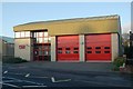
Kirkbymoorside fire station
Kirkbymoorside fire station, New Road, Kirkbymoorside, North Yorkshire
Image: © Kevin Hale
Taken: 6 Dec 2009
0.12 miles
10
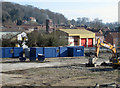
Railway station site cleared
Compare this view towards the fire station to one taken 4 years earlier from Ings Lane bridge. The site is now being redeveloped for housing. Image
Image: © Pauline E
Taken: 3 Apr 2011
0.12 miles