IMAGES TAKEN NEAR TO
Dale End, YORK, YO62 6ED
Introduction
This page details the photographs taken nearby to Dale End, YO62 6ED by members of the Geograph project.
The Geograph project started in 2005 with the aim of publishing, organising and preserving representative images for every square kilometre of Great Britain, Ireland and the Isle of Man.

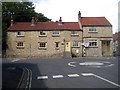
There are currently over 7.5m images from over14,400 individuals and you can help contribute to the project by visiting https://www.geograph.org.uk
Image Map
Images are licensed for reuse under creativecommons.org/licenses/by-sa/2.0
Notes
- Clicking on the map will re-center to the selected point.
- The higher the marker number, the further away the image location is from the centre of the postcode.
Image Listing (199 Images Found)
Images are licensed for reuse under creativecommons.org/licenses/by-sa/2.0
Image
Details
Distance
1

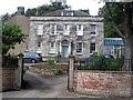
Low Hall at Kirkbymoorside
This substantial house is just beyond the Northern end of the main street.
It dates to the late 18th Century.
Image: © Colin Grice
Taken: 9 Nov 2007
0.02 miles
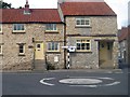
2
Low Hall, Dale End
A grade II listed house of 2 storeys with basement and attic, dated 1797. Fine ashlar front, rendered to sides and rear; Steps with cast-iron railings lead to a recessed door with open pediment on Tuscan columns. Raised band at basement level and above 2nd storey windows, the latter supporting a plain parapet. C20 flat-topped dormer in a concrete slab hipped roof, with chimney stacks either end.
LBS Number: 328397
Image: © Mike Kirby
Taken: 9 Jul 2011
0.03 miles
4
Start of Gillamoor Road
Looking uphill at the start of Gillamoor Road, Kirkbymoorside.
Image: © T Eyre
Taken: 29 Dec 2017
0.05 miles
5
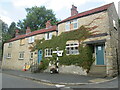
Stone built cottages at Dale End
At the top of the Market Place
Image: © Martin Dawes
Taken: 8 Jul 2021
0.05 miles
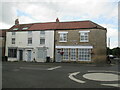
6
26-28, Dale End
A pair of early 19th century houses, (not listed).
Image: © Mike Kirby
Taken: 9 Jul 2011
0.06 miles
7
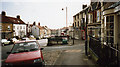
Road sign, Dale End
Original cast iron 'Yorks North Riding C C' road sign in Dale End.
Image: © Mike Kirby
Taken: 9 Jul 2011
0.06 miles
8
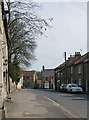
Houses on High Market Place
The road on the right is Dale End
Image: © Martin Dawes
Taken: 8 Jul 2021
0.06 miles
9
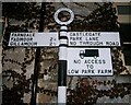
Old Direction Sign - Signpost by High Market Place, Kirkbymoorside
Annulus finial - 3 arms; NRYCC halo by the UC road, in parish of Kirkbymoorside (Ryedale District), junction of High Market Place, Dale End and Castlegate.
To be surveyed
Milestone Society National ID: YN_SE6986
Image: © Milestone Society
Taken: Unknown
0.06 miles
10
Kirkbymoorside Market Place
Looking south from the corner of Upper Market Place and Tinley Garth, down Market Place (the area is transformed on market day, Wednesday) to Piercy End, once Railway Street. Post Office on the right.
Image: © John Martin
Taken: 4 Feb 2007
0.06 miles