IMAGES TAKEN NEAR TO
Gawtersyke Lane, YORK, YO62 6DR
Introduction
This page details the photographs taken nearby to Gawtersyke Lane, YO62 6DR by members of the Geograph project.
The Geograph project started in 2005 with the aim of publishing, organising and preserving representative images for every square kilometre of Great Britain, Ireland and the Isle of Man.

There are currently over 7.5m images from over14,400 individuals and you can help contribute to the project by visiting https://www.geograph.org.uk
Image Map
Images are licensed for reuse under creativecommons.org/licenses/by-sa/2.0
Notes
- Clicking on the map will re-center to the selected point.
- The higher the marker number, the further away the image location is from the centre of the postcode.
Image Listing (50 Images Found)
Images are licensed for reuse under creativecommons.org/licenses/by-sa/2.0
Image
Details
Distance
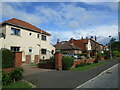
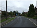
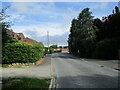
2
Road junction on outskirts of Kirkbymoorside
Image: © Phil Catterall
Taken: 30 Jul 2006
0.03 miles
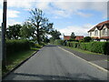
4
Ings Lane, Kirkbymoorside
Residential area on the south side of the little town.
Image: © Gordon Hatton
Taken: 6 Aug 2020
0.06 miles
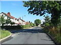
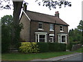
5
Ings Lane heading south from Kirkbymoorside
Image: © JThomas
Taken: 10 Sep 2012
0.06 miles
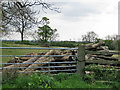
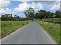
6
Ings Lane going south from Kirkbymoorside
It ends at South Ings Farm
Image: © Martin Dawes
Taken: 29 Jul 2021
0.07 miles
8
Ings Lane
Heading up to the A170 at Kirkbymoorside.
Image: © Pauline E
Taken: 20 Jun 2011
0.10 miles
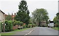
9
Ings Lane into Kirkbymoorside
The railway bridge in the distance now spans a dismantled line. It closed in 1964 and is now built on
Image: © Martin Dawes
Taken: 29 Jul 2021
0.11 miles
10
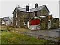
Kirkbymoorside Station
Along the dismantled NER Gilling & Pickering Branch line.
Image: © David Rogers
Taken: 4 Feb 2010
0.11 miles