IMAGES TAKEN NEAR TO
Bank Top, YORK, YO62 5YL
Introduction
This page details the photographs taken nearby to Bank Top, YO62 5YL by members of the Geograph project.
The Geograph project started in 2005 with the aim of publishing, organising and preserving representative images for every square kilometre of Great Britain, Ireland and the Isle of Man.

There are currently over 7.5m images from over14,400 individuals and you can help contribute to the project by visiting https://www.geograph.org.uk
Image Map
Images are licensed for reuse under creativecommons.org/licenses/by-sa/2.0
Notes
- Clicking on the map will re-center to the selected point.
- The higher the marker number, the further away the image location is from the centre of the postcode.
Image Listing (35 Images Found)
Images are licensed for reuse under creativecommons.org/licenses/by-sa/2.0
Image
Details
Distance
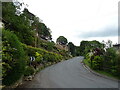
2
Don't stray from the footpath
This footpath goes above the village which is steeply down on the left.
Image: © Martin Dawes
Taken: 7 Aug 2013
0.10 miles
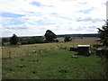
3
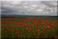
Poppies above Oswaldkirk
This is a field of oilseed rape (post flowering) which has a weed problem.
Despite the dull day the flowers glow and were noticeable from miles away.
Image: © Colin Grice
Taken: 18 Jun 2008
0.10 miles
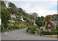
4
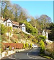
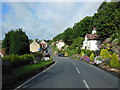
Hillside properties in Oswaldkirk
Oswaldkirk is a liner village strung out along the bottom of a steep scarp slope, which is the tail end of the Hambleton Hills. The B1363 makes a sharp turn here to climb to the top of the hill, whilst some properties cling to the steep hillside with exposed rock to their rear.
Image: © Gordon Hatton
Taken: 26 Dec 2017
0.11 miles
5
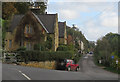
Former school, Oswaldkirk
The old school building with teachers' houses sits at the bottom of the bank. The school building was divided into three sections: what is now School House was the teacher's residence; what is now Southlands was the school; the corner property, now Laurel Cottage, was the home of the Headmaster, who was also the village registrar. Today most of the children of primary school age attend St Hilda's or St Benedict's schools in Ampleforth village, and when they are eleven they move on to Ryedale Comprehensive School at Nawton/Beadlam.
Image: © Pauline E
Taken: 27 Oct 2013
0.11 miles
6
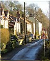
Lane in Oswaldkirk
This is a dead end lane running east from the main junction in the village.
Image: © Gordon Hatton
Taken: 26 Dec 2017
0.11 miles
7
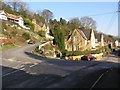
Oswaldkirk
The eastern end of the village.
The building on the inside of the bend is a former school.
Image: © Colin Grice
Taken: 10 Feb 2008
0.12 miles
8
Oswaldkirk Bank
The B1363 has a 1:7 gradient up the bank.
Image: © Pauline E
Taken: 27 Oct 2013
0.12 miles