IMAGES TAKEN NEAR TO
Acres Close, YORK, YO62 5DS
Introduction
This page details the photographs taken nearby to Acres Close, YO62 5DS by members of the Geograph project.
The Geograph project started in 2005 with the aim of publishing, organising and preserving representative images for every square kilometre of Great Britain, Ireland and the Isle of Man.

There are currently over 7.5m images from over14,400 individuals and you can help contribute to the project by visiting https://www.geograph.org.uk
Image Map
Images are licensed for reuse under creativecommons.org/licenses/by-sa/2.0
Notes
- Clicking on the map will re-center to the selected point.
- The higher the marker number, the further away the image location is from the centre of the postcode.
Image Listing (47 Images Found)
Images are licensed for reuse under creativecommons.org/licenses/by-sa/2.0
Image
Details
Distance
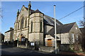
2
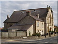
Old School House and Methodist Church, Helmsley
In Ashdale Road, view from the end of Carlton Road.
Image: © David Hawgood
Taken: 3 Sep 2007
0.12 miles
3
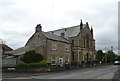
House and Methodist Church on Ashdale Road, Helmsley
Image: © JThomas
Taken: 4 Jul 2020
0.14 miles
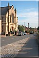
4
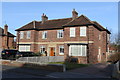
Helmsley Police Station
On Ashdale Road, Helmsley
Image: © Andrew Abbott
Taken: 24 Feb 2018
0.14 miles
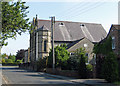
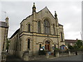
5
Helmsley Methodist Church
Opened in 1901.
Image: © Andrew Abbott
Taken: 24 Feb 2018
0.14 miles
6
Helmsley Methodist Church
On Ashdale Road.
Image: © Mick Garratt
Taken: 15 Sep 2012
0.14 miles
7
Helmsley Methodist Church
This is situated on the east side of Ashdale Road, south of the A170.
Image: © Pauline E
Taken: 4 Jun 2011
0.14 miles
8
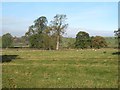
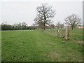
Ridge and furrow at Helmsley
Some distinct ridge and furrow undulations in a field just east of the town. The OS map here shows a series of long thin fields to the east of Carlton Road, suggesting that this area has been enclosed from what may well have been the community's common 'East Field' at some time in the distant past.
Image: © Gordon Hatton
Taken: 2 Nov 2016
0.15 miles
9
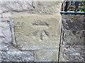
Ordnance Survey Cut Mark
This can be found on the wall of the Methodist Church in Helmsley.
For more detail see : http://www.bench-marks.org.uk/bm32735
Image: © Peter Wood
Taken: 30 Jul 2014
0.15 miles
10
Methodist Church in Ashdale Road, Helmsley
Viewed from the west.
Image: © Peter Wood
Taken: 30 Jul 2014
0.15 miles