IMAGES TAKEN NEAR TO
Church Street, YORK, YO62 5AD
Introduction
This page details the photographs taken nearby to Church Street, YO62 5AD by members of the Geograph project.
The Geograph project started in 2005 with the aim of publishing, organising and preserving representative images for every square kilometre of Great Britain, Ireland and the Isle of Man.

There are currently over 7.5m images from over14,400 individuals and you can help contribute to the project by visiting https://www.geograph.org.uk
Image Map
Images are licensed for reuse under creativecommons.org/licenses/by-sa/2.0
Notes
- Clicking on the map will re-center to the selected point.
- The higher the marker number, the further away the image location is from the centre of the postcode.
Image Listing (478 Images Found)
Images are licensed for reuse under creativecommons.org/licenses/by-sa/2.0
Image
Details
Distance
1
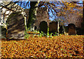
No?s 14, 15 & 17, Church Street
A grade II listed, three storey warehouse, c1780, converted to houses by 1830. Constructed in coursed limestone rubble, a slate roof with stone and brick stacks. No.14 on the left, entrances to No's 15 and 17 inserted into the former carriage arch. LBS No: 328278
No.15, currently Bowley & Jackson, Interiors and gift shop.
No.17, currently Cinnamon Twist Bakery, where bread is made daily to traditional recipes.
Image: © Mike Kirby
Taken: 8 Oct 2014
0.00 miles
2
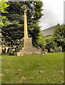
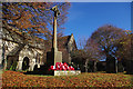
Helmsley War Memorial
The War Memorial outside All Saints' Church.
Image: © David Dixon
Taken: 3 Aug 2011
0.02 miles
4
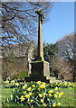
War memorial, Helmsley
Situated in All Saints churchyard.
Image: © Pauline E
Taken: 7 Apr 2011
0.02 miles
5
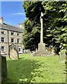
The War Memorial, Helmsley
The free-standing hooded cross is in the grounds of All Saints’ Church. The memorial commemorates the residents of Helmsley who were killed or missing in the First World War (36 names) and the Second World War (4 names).
Image: © David Dixon
Taken: 3 Aug 2024
0.02 miles
6
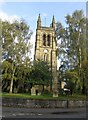
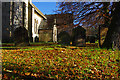
Church of All Saints, Church Street
A grade II* listed church dated 1866-9, incorporating C12, C13 and C14 features from an earlier church on the same site. The west tower, shown, comprises of three stages with C13 fabric surviving to second stage within a C19 rebuild. LBS No: 328277
Image: © Mike Kirby
Taken: 8 Oct 2014
0.02 miles
7
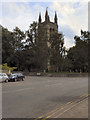
The Church of All Saints, Helmsley
The Church of All Saints at Helmsley is a Grade II* Listed Building (http://www.britishlistedbuildings.co.uk/en-328277-church-of-all-saints-helmsley ).
According to the 19th century wall-paintings in the north aisle of the church, a Christian church has existed in Helmsley since AD 200; There was certainly one on this site by the time of the Norman Conquest. (There's a 10th century hog-back tombstone in the porch and an entry in the Domesday Book of 1086.)
The present building's chancel arch, one of the largest in Yorkshire, dates from the 12th century (as does its counterpart over the entrance). Otherwise the handsome present day building is largely the result of major restoration in Victorian times, with the stained glass as well as the murals from this period too.
http://www.helmsleyparish.org.uk/AllSaintsHelmsley.htm Helmsley Parish
Image: © David Dixon
Taken: 3 Aug 2011
0.02 miles
8
War memorial, All Saints Church, Helmsley
The wreaths were laid this morning.
Image: © Ian Taylor
Taken: 11 Nov 2012
0.02 miles