IMAGES TAKEN NEAR TO
Hovingham, YORK, YO62 4JR
Introduction
This page details the photographs taken nearby to YO62 4JR by members of the Geograph project.
The Geograph project started in 2005 with the aim of publishing, organising and preserving representative images for every square kilometre of Great Britain, Ireland and the Isle of Man.

There are currently over 7.5m images from over14,400 individuals and you can help contribute to the project by visiting https://www.geograph.org.uk
Image Map
Images are licensed for reuse under creativecommons.org/licenses/by-sa/2.0
Notes
- Clicking on the map will re-center to the selected point.
- The higher the marker number, the further away the image location is from the centre of the postcode.
Image Listing (8 Images Found)
Images are licensed for reuse under creativecommons.org/licenses/by-sa/2.0
Image
Details
Distance
1
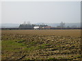
View over farmland to Tuft House Farm
Image: © Phil Catterall
Taken: 28 Mar 2007
0.00 miles
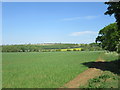
2
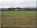
Over fields to Tuft House Farm
With Caulkleys Bank in the distance
Image: © Martin Dawes
Taken: 24 Apr 2013
0.08 miles
3
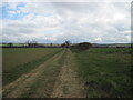
Farm track and Bridleway from South Holme Farm
Image: © Martin Dawes
Taken: 24 Apr 2013
0.16 miles
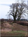
4
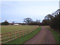
Lane to Tuft House Farm
Surfaced lane to the farm, and also the line of a bridleway.
Image: © Gordon Hatton
Taken: 17 Feb 2012
0.17 miles
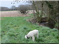
6
Footpath sign near Tuft House
At this point the bridleway turns left towards South Holme Farm, whilst a footpath to Fryton goes straight ahead. Another oddity on the map here is a short stretch of bridleway that appears to go nowhere.
Image: © Gordon Hatton
Taken: 17 Feb 2012
0.20 miles
8
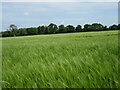
Near Tuft House Farm
Looking NE from the bridleway.
Image: © T Eyre
Taken: 17 May 2022
0.23 miles