IMAGES TAKEN NEAR TO
Gilling East, YORK, YO62 4BS
Introduction
This page details the photographs taken nearby to YO62 4BS by members of the Geograph project.
The Geograph project started in 2005 with the aim of publishing, organising and preserving representative images for every square kilometre of Great Britain, Ireland and the Isle of Man.

There are currently over 7.5m images from over14,400 individuals and you can help contribute to the project by visiting https://www.geograph.org.uk
Image Map
Images are licensed for reuse under creativecommons.org/licenses/by-sa/2.0
Notes
- Clicking on the map will re-center to the selected point.
- The higher the marker number, the further away the image location is from the centre of the postcode.
Image Listing (6 Images Found)
Images are licensed for reuse under creativecommons.org/licenses/by-sa/2.0
Image
Details
Distance
1
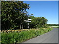
Road to Coulton Lane End Thorn Tree Farm Farm on left
A lot of traffic through here, know your way and it is a cross country route from Easingwold to Hovingham
Image: © Martin Dawes
Taken: 13 Jun 2015
0.18 miles

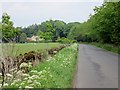
3

Newly shorn sheep near Thorn Tree Farm
To the right the edge of Blackdale Plantation
Image: © Martin Dawes
Taken: 13 Jun 2015
0.20 miles
4

Road to Yearsley
A well used country road that links the B1257 at Hovingham with Easingwold via either Yearsley or Brandsby.
Image: © Gordon Hatton
Taken: 3 Feb 2013
0.21 miles