IMAGES TAKEN NEAR TO
Crayke, YORK, YO61 4TW
Introduction
This page details the photographs taken nearby to YO61 4TW by members of the Geograph project.
The Geograph project started in 2005 with the aim of publishing, organising and preserving representative images for every square kilometre of Great Britain, Ireland and the Isle of Man.

There are currently over 7.5m images from over14,400 individuals and you can help contribute to the project by visiting https://www.geograph.org.uk
Image Map
Images are licensed for reuse under creativecommons.org/licenses/by-sa/2.0
Notes
- Clicking on the map will re-center to the selected point.
- The higher the marker number, the further away the image location is from the centre of the postcode.
Image Listing (21 Images Found)
Images are licensed for reuse under creativecommons.org/licenses/by-sa/2.0
Image
Details
Distance
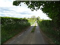
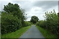
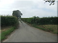
1
Towards Stonefield House
Looking along Rookery Lane.
Image: © DS Pugh
Taken: 15 Aug 2021
0.02 miles
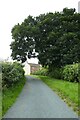
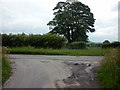
2
Narrow Lane leading towards Stone Field House
Narrow thoroughfare leading off Crayke Lane
Image: © Chris Heaton
Taken: 11 Mar 2020
0.05 miles
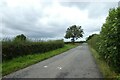
3
Towards Crayke Lane
Looking along Rookery Lane towards the junction with Crayke Lane.
Image: © DS Pugh
Taken: 15 Aug 2021
0.07 miles
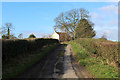
5
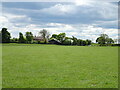
Grazing towards Stone Field House Farm
Off Binsley Lane.
Image: © JThomas
Taken: 16 May 2020
0.12 miles
6
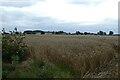
Field beside Binsley Lane
Looking across a wheat field.
Image: © DS Pugh
Taken: 15 Aug 2021
0.16 miles
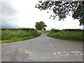
8
Towards Binsley Lane
Looking along Crayke Lane towards the junction with Binsley Lane.
Image: © DS Pugh
Taken: 15 Aug 2021
0.17 miles