IMAGES TAKEN NEAR TO
Crayke, YORK, YO61 4TR
Introduction
This page details the photographs taken nearby to YO61 4TR by members of the Geograph project.
The Geograph project started in 2005 with the aim of publishing, organising and preserving representative images for every square kilometre of Great Britain, Ireland and the Isle of Man.

There are currently over 7.5m images from over14,400 individuals and you can help contribute to the project by visiting https://www.geograph.org.uk
Image Map (Loading...)


Getting Data...Please wait
Leaflet Map data © OpenStreetMap
Images are licensed for reuse under creativecommons.org/licenses/by-sa/2.0
Notes
- Clicking on the map will re-center to the selected point.
- The higher the marker number, the further away the image location is from the centre of the postcode.
Image Listing (10 Images Found)
Images are licensed for reuse under creativecommons.org/licenses/by-sa/2.0
Image
Details
Distance
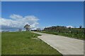
1
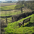
Hilltop seat
Fine views to be had from this position but visibility was not good today.
Image: © Pauline E
Taken: 28 Feb 2013
0.10 miles
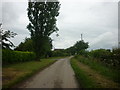
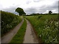
3
Rookery Lane near Providence Farm
Looking south along Rookery Lane.
Image: © DS Pugh
Taken: 15 Aug 2021
0.16 miles
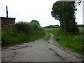
6

Junction with Chesler Pit Lane
Looking along Rookery Lane with Chesler Pit Lane on the left.
Image: © DS Pugh
Taken: 15 Aug 2021
0.17 miles
7
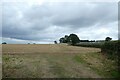
Field beside Chesler Pit Lane
Looking across a field from Rookery Lane.
Image: © DS Pugh
Taken: 15 Aug 2021
0.18 miles
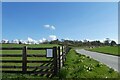
8
Drive to Mount Pleasant Farm
Leading north from Crayke Road.
Image: © DS Pugh
Taken: 3 Apr 2022
0.21 miles
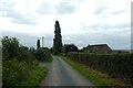
9
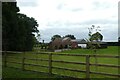
Rookery House
Looking towards a farm beside Rookery Lane.
Image: © DS Pugh
Taken: 15 Aug 2021
0.23 miles
10
Road to Crayke
Looking towards the village of Crayke standing on the hill.
Image: © DS Pugh
Taken: 3 Apr 2022
0.23 miles