IMAGES TAKEN NEAR TO
Brandsby, YORK, YO61 4RW
Introduction
This page details the photographs taken nearby to YO61 4RW by members of the Geograph project.
The Geograph project started in 2005 with the aim of publishing, organising and preserving representative images for every square kilometre of Great Britain, Ireland and the Isle of Man.

There are currently over 7.5m images from over14,400 individuals and you can help contribute to the project by visiting https://www.geograph.org.uk
Image Map (Loading...)


Getting Data...Please wait
Leaflet Map data © OpenStreetMap
Images are licensed for reuse under creativecommons.org/licenses/by-sa/2.0
Notes
- Clicking on the map will re-center to the selected point.
- The higher the marker number, the further away the image location is from the centre of the postcode.
Image Listing (5 Images Found)
Images are licensed for reuse under creativecommons.org/licenses/by-sa/2.0
Image
Details
Distance
1
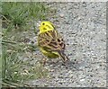
Yellowhammer
A Yellowhammer on the access road to Low Farm.
Image: © T Eyre
Taken: 3 Apr 2022
0.06 miles
3
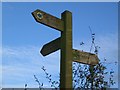
Three way footpath junction fingerpost
NNE for Bransby, SE for Whenby and WNW for Seaves.
Image: © Phil Catterall
Taken: 6 Nov 2007
0.15 miles
4
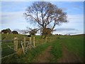
Field corner on Bridleway south of Low Farm
Image: © Phil Catterall
Taken: 6 Nov 2007
0.20 miles
5
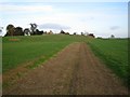
Unmapped earth track near Spellar Park
A number of hedgerows have been "grubbed out" in this area. The Bridleway shown on maps as entering grid square SE5970 has therefore been rerouted down this earth track in grid square SE5971. The bridleway previously went through SE5970 (as shown on Explorer and Landranger maps.) The original line of the route had been overplanted with a winter crop in November 2007.
Image: © Phil Catterall
Taken: 6 Nov 2007
0.22 miles