IMAGES TAKEN NEAR TO
Helperby, YORK, YO61 2QT
Introduction
This page details the photographs taken nearby to YO61 2QT by members of the Geograph project.
The Geograph project started in 2005 with the aim of publishing, organising and preserving representative images for every square kilometre of Great Britain, Ireland and the Isle of Man.

There are currently over 7.5m images from over14,400 individuals and you can help contribute to the project by visiting https://www.geograph.org.uk
Image Map (Loading...)


Getting Data...Please wait
Leaflet Map data © OpenStreetMap
Images are licensed for reuse under creativecommons.org/licenses/by-sa/2.0
Notes
- Clicking on the map will re-center to the selected point.
- The higher the marker number, the further away the image location is from the centre of the postcode.
Image Listing (5 Images Found)
Images are licensed for reuse under creativecommons.org/licenses/by-sa/2.0
Image
Details
Distance
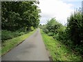
1
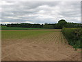
Track alongside Myton Far End Plantation
Off the lane toward Helperby
Image: © Martin Dawes
Taken: 8 Sep 2017
0.03 miles
2
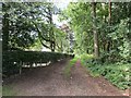
Helperby & Myton Lane
Helperby & Myton Lane near The Carrs and looking towards Myton Far End Plantation.
Image: © Darren Haddock
Taken: 9 Oct 2006
0.04 miles
3
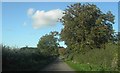
Passing place - Myton Lane
A passing place on the lane running from Myton to Helperby.
Image: © DS Pugh
Taken: 5 Aug 2007
0.14 miles
4
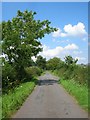
Lane toward Helperby
From Myton on Swale
Image: © Martin Dawes
Taken: 8 Sep 2017
0.19 miles