
IMAGES TAKEN NEAR TO
Alne Cross, YORK, YO61 1SD
Introduction
This page details the photographs taken nearby to Alne Cross, YO61 1SD by members of the Geograph project.
The Geograph project started in 2005 with the aim of publishing, organising and preserving representative images for every square kilometre of Great Britain, Ireland and the Isle of Man.

There are currently over 7.5m images from over14,400 individuals and you can help contribute to the project by visiting https://www.geograph.org.uk
Image Map
Images are licensed for reuse under creativecommons.org/licenses/by-sa/2.0
Notes
- Clicking on the map will re-center to the selected point.
- The higher the marker number, the further away the image location is from the centre of the postcode.
Image Listing (26 Images Found)
Images are licensed for reuse under creativecommons.org/licenses/by-sa/2.0
Image
Details
Distance
1
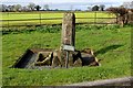
The Alne Cross
A small plaque beside the ancient relic states:-
"This stone is one of several erected during the plague of the 17th century. Here the country people brought their market produce to avoid taking it into the infected town. Money was left into the disinfected trough."
Image: © Chris Heaton
Taken: 13 Mar 2017
0.05 miles
2
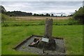
Alne Cross
Probably the stump of a medieval cross, it found later use as a plague stone. Commercial transactions took place here to quarantine the village. Goods were left here and payment placed in the trough on the left, probably in vinegar or other liquid believed to protect against infection. (Knowledge of the causes of infectious disease was at least 200 years in the future.)
Image: © Richard Webb
Taken: 11 Aug 2016
0.06 miles
3

Old Wayside Cross and Guidestone south of Alne village
The Plague Cross, a Wayside Cross with an old shaft and base used as a Guidestone. Set on the southwest side of a crossroads of roads from Tollerton to Flawith and Alne to Youlton, south of the village in Alne parish.
Inscription reads: South face – YORK // west face – WEA / THERBY // North face - TOPLIFF // east face - (EASING) / WOOD (now Easingwold)
Grade II listed by Historic England (see https://historicengland.org.uk/listing/the-list/list-entry/1151296 ).
See also https://www.geograph.org.uk/photo/1856026 , https://www.geograph.org.uk/photo/5314383 , https://www.geograph.org.uk/photo/6737368 , https://www.geograph.org.uk/photo/5314383 and https://www.geograph.org.uk/photo/5108926.
Milestone Society National ID: YNHA_ALN (Wayside Cross) and YN_XALN (Guidestone)
Image: © J Howat
Taken: Unknown
0.06 miles
4

Old Guide stone, on an unclassified road, X rds S of Alne
Located on the South side of road, SW corner of cross roads Tollerton to Flawith and Alne to Youlton. Actually a plague cross doubling as a guide stone, 17th century. Alternative views see https://www.geograph.org.uk/photo/1856026 & https://www.geograph.org.uk/photo/5314383 & https://www.geograph.org.uk/photo/6737368 & https://www.geograph.org.uk/photo/5314383 & https://www.geograph.org.uk/photo/5108926
Inscription reads: South face - YORK // west face – WEA / THERBY // North face - TOPLIFF // east face - (EASING) / WOOD (now Easingwold)
Grade II listed by Historic England. (see https://historicengland.org.uk/listing/the-list/list-entry/1151296 )
Milestone Society National ID: YN_XALN
Image: © Christine Minto
Taken: Unknown
0.06 miles

6
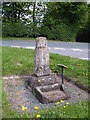
Plague Stone, Alne
The Plague Stone may well be considerably older than the 17th century, the period from which it gets its name. Note the stone tray for money to be left as payment for supplies for the villagers of nearby Alne. A few modern coins are scattered in the tray.
Image: © Gordon Hatton
Taken: 12 May 2010
0.06 miles
7
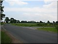
Junction
Aldwalk behind, Alne to the left, Youlton to the right and Tollerton straight ahead.
Image: © DS Pugh
Taken: 15 Jun 2006
0.09 miles

10
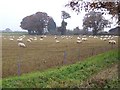
Sheep folded on root crops
Near Alne.
Image: © Oliver Dixon
Taken: 16 Nov 2018
0.15 miles