
IMAGES TAKEN NEAR TO
Main Street, YORK, YO61 1DW
Introduction
This page details the photographs taken nearby to Main Street, YO61 1DW by members of the Geograph project.
The Geograph project started in 2005 with the aim of publishing, organising and preserving representative images for every square kilometre of Great Britain, Ireland and the Isle of Man.

There are currently over 7.5m images from over14,400 individuals and you can help contribute to the project by visiting https://www.geograph.org.uk
Image Map
Images are licensed for reuse under creativecommons.org/licenses/by-sa/2.0
Notes
- Clicking on the map will re-center to the selected point.
- The higher the marker number, the further away the image location is from the centre of the postcode.
Image Listing (52 Images Found)
Images are licensed for reuse under creativecommons.org/licenses/by-sa/2.0
Image
Details
Distance


3
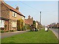
Cottages - Sutton on the Forest
A plant stall stands in front of some cottages in the village of Sutton on the Forest.
Image: © DS Pugh
Taken: 28 Mar 2007
0.06 miles
4
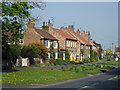
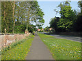
Cottages, Sutton on the Forest
View along the B1363.
Image: © Pauline E
Taken: 22 Apr 2011
0.08 miles
5
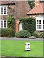
Confusion in Sutton
Is this a plot to send travellers in the wrong direction? This milestone on the north side of the village street clearly shows the way to Helmsley is to the left and that to York is to the right - the opposite of what is correct. One can only assume that at some time in the past the milestone has been moved from one side of the road to the other.
Image: © Gordon Hatton
Taken: 18 Sep 2018
0.10 miles
6
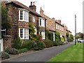
Village houses in Sutton on the Forest
Houses on the north side of the village street which runs W-E for some 700 metres. Typical Vale of York houses of brick with pantile roofs.
Image: © Gordon Hatton
Taken: 18 Sep 2018
0.10 miles
8
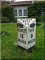
Old milepost
On the B1363, Main Street, Sutton on the Forest. The HD on the bevel denotes Highway District so it was set up in the late 19C. Mattison's foundry cast many of these posts with the hands pointing in the wrong direction. On this post there is the remnant of the 'new' hand on the Helmsley face and fixing pegs can be seen.
Image: © Chris Minto
Taken: 6 Jun 2021
0.11 miles
9
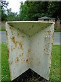
Old milepost
The back of the post in Main Street, Sutton on the Forest, showing the foundry name, F Mattison & Co/Bedale on the right hand side. Near the top on both sides can be seen the pegs where the correctly pointing hands were fixed after they had been cast pointing the wrong way. This post was uprooted in 2008. It was found and repainted by a Milestone Society member and reset in March 2009.
Image: © Chris Minto
Taken: 6 Jun 2021
0.11 miles
10
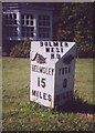
Old Milestone, B1363, Main Street, Sutton-on-the-Forest
In front of Laughton House. Located on the North side of road, on grass verge. Cast iron post, Bedale casting design, 19th century. Alternative view see http://www.geograph.org.uk/photo/5911942
Inscription reads: {hand to left} / HELMSLEY / 15 / MILES // {hand to right} / YORK / 8 / MILES // BULMER / WEST / H. D // F MATTISON & Co / BEDALE
Grade II listed by Historic England. see https://historicengland.org.uk/listing/the-list/list-entry/1260372
Milestone Society National ID: YN_YOHM08
Image: © Christine Minto
Taken: 8 Feb 2006
0.11 miles