IMAGES TAKEN NEAR TO
Leppington, YORK, YO60 7LP
Introduction
This page details the photographs taken nearby to Leppington, YO60 7LP by members of the Geograph project.
The Geograph project started in 2005 with the aim of publishing, organising and preserving representative images for every square kilometre of Great Britain, Ireland and the Isle of Man.

There are currently over 7.5m images from over14,400 individuals and you can help contribute to the project by visiting https://www.geograph.org.uk
Image Map
Images are licensed for reuse under creativecommons.org/licenses/by-sa/2.0
Notes
- Clicking on the map will re-center to the selected point.
- The higher the marker number, the further away the image location is from the centre of the postcode.
Image Listing (9 Images Found)
Images are licensed for reuse under creativecommons.org/licenses/by-sa/2.0
Image
Details
Distance
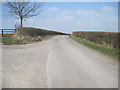
1
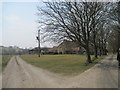
Farm traffic to the left
Access road into Leppington Grange
Image: © Martin Dawes
Taken: 10 Apr 2013
0.04 miles
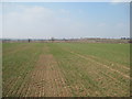
2
Bridleway over field to Mook Street
Little sign on the ground
Image: © Martin Dawes
Taken: 10 Apr 2013
0.10 miles
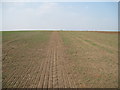
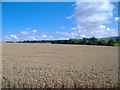
3
Over field to lane to Leppington
The dark mass of Leppington Wood can be seen in the centre distance
Image: © Martin Dawes
Taken: 10 Apr 2013
0.12 miles
4
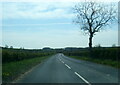
Lane to Mook Street at farm junction
The track to the left goes to Leppington Grange
Image: © Martin Dawes
Taken: 10 Apr 2013
0.15 miles

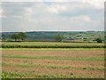
6
Bridleway over field to Mook Street (2)
The hedge at the end of the field borders the road
Image: © Martin Dawes
Taken: 10 Apr 2013
0.19 miles
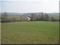
8
Acklam from Mook Street
There is a road running along the hedgerow.
Image: © DS Pugh
Taken: 20 Jun 2006
0.23 miles