IMAGES TAKEN NEAR TO
Huttons Ambo, YORK, YO60 7JB
Introduction
This page details the photographs taken nearby to YO60 7JB by members of the Geograph project.
The Geograph project started in 2005 with the aim of publishing, organising and preserving representative images for every square kilometre of Great Britain, Ireland and the Isle of Man.

There are currently over 7.5m images from over14,400 individuals and you can help contribute to the project by visiting https://www.geograph.org.uk
Image Map
Images are licensed for reuse under creativecommons.org/licenses/by-sa/2.0
Notes
- Clicking on the map will re-center to the selected point.
- The higher the marker number, the further away the image location is from the centre of the postcode.
Image Listing (13 Images Found)
Images are licensed for reuse under creativecommons.org/licenses/by-sa/2.0
Image
Details
Distance
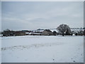
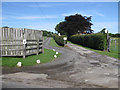
2
Oakcliffe Farm from the railway
Oakcliffe Farm on Where's the path and Low Farm on OS map
Image: © John Firth
Taken: 10 May 2014
0.03 miles
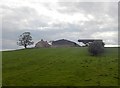
3
Walking the Howardian Hills and beyond #17
The track to Low Farm.
Image: © Ian S
Taken: 28 Aug 2010
0.05 miles
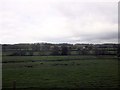
4
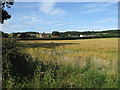
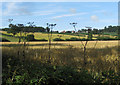
Barley field near Low Farm
Turning golden in the August sunshine.
Image: © Pauline E
Taken: 6 Aug 2013
0.06 miles
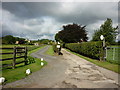
5
Entrance to Low Farm
To the north of Huttons Ambo.
Image: © Pauline E
Taken: 6 Aug 2013
0.07 miles
8
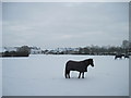
Low Farm and Friends
We were "investigated" for food but got through unscathed!
Image: © Martin Dawes
Taken: 12 Feb 2012
0.13 miles
9
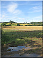
Puddles after recent rain
Crop fields near Huttons Ambo.
Image: © Pauline E
Taken: 6 Aug 2013
0.17 miles
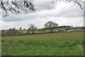
10
Ripening barley crop
View to High Hutton.
Image: © Pauline E
Taken: 6 Aug 2013
0.18 miles