IMAGES TAKEN NEAR TO
Bulmer, YORK, YO60 7ES
Introduction
This page details the photographs taken nearby to YO60 7ES by members of the Geograph project.
The Geograph project started in 2005 with the aim of publishing, organising and preserving representative images for every square kilometre of Great Britain, Ireland and the Isle of Man.

There are currently over 7.5m images from over14,400 individuals and you can help contribute to the project by visiting https://www.geograph.org.uk
Image Map
Images are licensed for reuse under creativecommons.org/licenses/by-sa/2.0
Notes
- Clicking on the map will re-center to the selected point.
- The higher the marker number, the further away the image location is from the centre of the postcode.
Image Listing (9 Images Found)
Images are licensed for reuse under creativecommons.org/licenses/by-sa/2.0
Image
Details
Distance
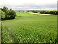
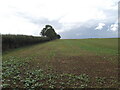
3
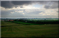
Low Fields near Bulmer, North Yorkshire
The view southwest to Low Fields near Bulmer on a cloudy October day. On a clear day you would be able to see all the way to York from this part of the footpath.
Image: © Uncredited
Taken: 19 Oct 2005
0.10 miles
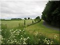
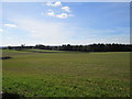
5
Into Scugdale from field edge footpath
Image: © Martin Dawes
Taken: 17 Jun 2015
0.20 miles
6
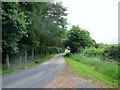
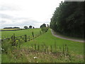
Access road from East Ings
The footpath over the fields from Bulmer comes out to my right
Image: © Martin Dawes
Taken: 17 Jun 2015
0.20 miles
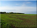
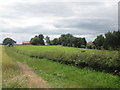
9
A southward field path
An ageing sign at the start informs one that the footbridge is no longer at the bottom of the hill. It was too far to go and find out if it was still missing!
Image: © David Brown
Taken: 9 Sep 2022
0.24 miles