IMAGES TAKEN NEAR TO
The Green, YORK, YO60 6SB
Introduction
This page details the photographs taken nearby to The Green, YO60 6SB by members of the Geograph project.
The Geograph project started in 2005 with the aim of publishing, organising and preserving representative images for every square kilometre of Great Britain, Ireland and the Isle of Man.

There are currently over 7.5m images from over14,400 individuals and you can help contribute to the project by visiting https://www.geograph.org.uk
Image Map
Images are licensed for reuse under creativecommons.org/licenses/by-sa/2.0
Notes
- Clicking on the map will re-center to the selected point.
- The higher the marker number, the further away the image location is from the centre of the postcode.
Image Listing (70 Images Found)
Images are licensed for reuse under creativecommons.org/licenses/by-sa/2.0
Image
Details
Distance
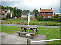
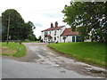
1
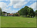
Village green, Sheriff Hutton
An attractive feature of the village away from the main through routes.
Image: © Gordon Hatton
Taken: 13 Aug 2021
0.05 miles
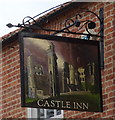
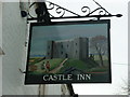
3
The Castle Inn, Sheriff Hutton
A Sam Smith's public house.
Image: © Ian S
Taken: 22 Jun 2013
0.06 miles
4

The Castle Inn, Sheriff Hutton
A Sam Smith's public house.
Image: © Ian S
Taken: 22 Jun 2013
0.06 miles
5
The Castle Inn, Sheriff Hutton
A Sam Smith's public house.
Image: © Ian S
Taken: 22 Jun 2013
0.06 miles
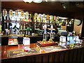
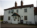
6
The Castle Inn, a Sam Smith's pub in Sheriff Hutton
Image: © Ian S
Taken: 8 Feb 2011
0.06 miles
7
The Castle Inn, a Sam Smith's pub in Sheriff Hutton
Image: © Ian S
Taken: 8 Feb 2011
0.06 miles
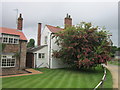
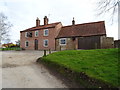
8
The beer garden at the Castle Inn, Sheriff Hutton
A Sam Smith's public house.
Image: © Ian S
Taken: 22 Jun 2013
0.06 miles
10
The Castle Inn, Sheriff Hutton
A Sam Smith's public house.
Image: © Ian S
Taken: 22 Jun 2013
0.06 miles