IMAGES TAKEN NEAR TO
Ashbourne Close, YORK, YO51 9JJ
Introduction
This page details the photographs taken nearby to Ashbourne Close, YO51 9JJ by members of the Geograph project.
The Geograph project started in 2005 with the aim of publishing, organising and preserving representative images for every square kilometre of Great Britain, Ireland and the Isle of Man.

There are currently over 7.5m images from over14,400 individuals and you can help contribute to the project by visiting https://www.geograph.org.uk
Image Map
Images are licensed for reuse under creativecommons.org/licenses/by-sa/2.0
Notes
- Clicking on the map will re-center to the selected point.
- The higher the marker number, the further away the image location is from the centre of the postcode.
Image Listing (28 Images Found)
Images are licensed for reuse under creativecommons.org/licenses/by-sa/2.0
Image
Details
Distance
1
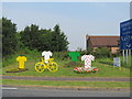
Ready for 'Le Tour'
Tour de France themed flower beds etc at the southern end of Boroughbridge.
Image: © Gordon Hatton
Taken: 2 Jul 2014
0.05 miles
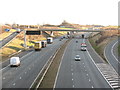
2
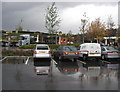
Boroughbridge Service Station
Situated near the A1. Photo taken at MR: SE39486563
Image: © Andy Beecroft
Taken: 25 Oct 2005
0.08 miles
3
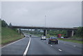
The A1(M) northbound
At Junction 48 near Boroughbridge.
Image: © JThomas
Taken: 30 Nov 2013
0.10 miles
4

A Boroughbridge Milestone
Located on the A168 one mile south of Boroughbridge.
Image: © David Rogers
Taken: 19 Nov 2008
0.10 miles
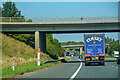
5

Road over Motorway
From the A168 turn left and you can join the A1M or carry on into the Yorkshire Dales
Image: © Martin Dawes
Taken: 21 Sep 2011
0.11 miles
6
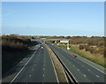
Junction 48
Junction 48 on A1[M] where the motorway links with the A168 and A6055 between Boroughbridge and Minskip.
Image: © Gordon Hatton
Taken: 10 Dec 2007
0.11 miles
7
Boroughbridge : A1(M)
Passing Junction 48.
Image: © Lewis Clarke
Taken: 21 Sep 2020
0.12 miles
8
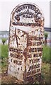
Old Milestone, on the A168 (old A1)
S of Boroughbridge on old A1. Located on the West side of road, near traffic island at A6055 junction, in front of Highways depot. Metal plate attached to stone post, WR Casting design, erected by Ferrybridge & Boroughbridge turnpike trust, 19th century. Alternative views see http://www.geograph.org.uk/photo/1052180 & http://www.geograph.org.uk/photo/2633802
Inscription reads: BOROUGH / BRIDGE / 1 MILE // WETHERBY / 11¼ MILES / ABERFORD / 18½ MILES / FERRY / BRIDGE / 28 MILES / DONCASTER / 41 MILES // FERRYBRIDGE / & / BOROUGHBRIDGE / ROAD / BOROUGHBRIDGE
Milestone Society National ID: YN_FBBB28
Image: © Christine Minto
Taken: 29 Dec 2005
0.12 miles
9
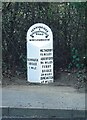
Old milestone
This most northerly of the West Riding CC milestones on the A168, old A1, even older Great North Road, just south of Boroughbridge is near the Highways depot just south of the A168/A6055 traffic island. Prior to 1974 the River Ure which runs through Boroughbridge was the boundary of the West and North Ridings, but since then the town has been part of North Yorkshire. Milestone Society members from Knaresborough and York have painted this milestone as needed over many years.
Milestone Society National ID: YN_FBBB28
Image: © Chris Minto
Taken: 29 Sep 2018
0.12 miles