IMAGES TAKEN NEAR TO
Back Lane, YORK, YO51 9FE
Introduction
This page details the photographs taken nearby to Back Lane, YO51 9FE by members of the Geograph project.
The Geograph project started in 2005 with the aim of publishing, organising and preserving representative images for every square kilometre of Great Britain, Ireland and the Isle of Man.

There are currently over 7.5m images from over14,400 individuals and you can help contribute to the project by visiting https://www.geograph.org.uk
Image Map
Images are licensed for reuse under creativecommons.org/licenses/by-sa/2.0
Notes
- Clicking on the map will re-center to the selected point.
- The higher the marker number, the further away the image location is from the centre of the postcode.
Image Listing (19 Images Found)
Images are licensed for reuse under creativecommons.org/licenses/by-sa/2.0
Image
Details
Distance
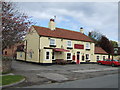
3
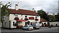
The Fox and Hounds at Langthorpe
Pleasant pub in a quiet village just across the river from Boroughbridge.
Image: © Gordon Hatton
Taken: 31 Aug 2007
0.10 miles
4
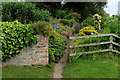
On the Riverside Path at Langthorpe
This path follows the northern bank of the River Ure towards Boroughbridge. It passes through several back gardens to reach its destination.
Many of the residents have gone to much trouble - nay, have pulled all the stops out to make it as pleasant an experience as possible for users of this right of way. Colourful flowers, plants and bushes have been neatly arranged around the route - an example of this being portrayed in the photograph.
Image: © Chris Heaton
Taken: 23 Jun 2015
0.12 miles
5
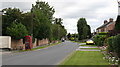
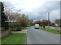
Skelton Road, Langthorpe
The main street of this mainly residential village on the banks of the Ure.
Image: © Gordon Hatton
Taken: 31 Aug 2007
0.13 miles
6
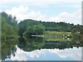
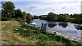
Moorings, River Ure, Langthorpe
Seen from a boat heading upstream [locally west].
Image: © Christine Johnstone
Taken: 9 Aug 2018
0.13 miles
8
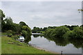
The River Ure at Langthorpe
Following the riverside path towards Boroughbridge
Image: © Chris Heaton
Taken: 23 Jun 2015
0.14 miles
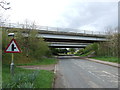
10
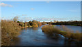
River Ure in flood
The River Ure as seen from the bridge carrying the A168 across its flow; the river is the left side stretch of water, the right side is floodwater. The buildings are in the village of Boroughbridge through which the river is about to pass.
Image: © Trevor Littlewood
Taken: 24 Dec 2013
0.16 miles