IMAGES TAKEN NEAR TO
Aldborough, Boroughbridge, YORK, YO51 9EZ
Introduction
This page details the photographs taken nearby to YO51 9EZ by members of the Geograph project.
The Geograph project started in 2005 with the aim of publishing, organising and preserving representative images for every square kilometre of Great Britain, Ireland and the Isle of Man.

There are currently over 7.5m images from over14,400 individuals and you can help contribute to the project by visiting https://www.geograph.org.uk
Image Map
Images are licensed for reuse under creativecommons.org/licenses/by-sa/2.0
Notes
- Clicking on the map will re-center to the selected point.
- The higher the marker number, the further away the image location is from the centre of the postcode.
Image Listing (8 Images Found)
Images are licensed for reuse under creativecommons.org/licenses/by-sa/2.0
Image
Details
Distance
2

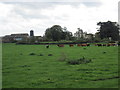
Aldborough Grange
along Soursikes Field Road.
Image: © David Rogers
Taken: 17 Aug 2010
0.04 miles
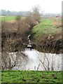
3
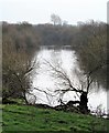
Downstream along the Ure
A section of the Ure between Ellenthorpe Lodge and Grange Farm.
Image: © Gordon Hatton
Taken: 21 Jan 2019
0.16 miles
4
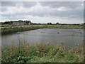
Fish Farm and Grange Farm
From the riverside footpath which goes between the river and the fish ponds
Image: © Martin Dawes
Taken: 21 Sep 2011
0.18 miles
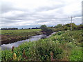
6
Field drain discharging into the Ure
Follow this drain upstream and it appears to be called Low Common Drain.
Image: © Gordon Hatton
Taken: 21 Jan 2019
0.21 miles
7
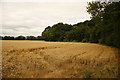
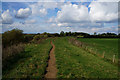
Bernard's Plantation
seen from Soursikes Field Road.
Image: © David Rogers
Taken: 17 Aug 2010
0.23 miles
8
River Ure
Heavy growth along the bank obscures much of the river
Image: © David Brown
Taken: 13 Jul 2020
0.23 miles