IMAGES TAKEN NEAR TO
Baileywood Lane, YORK, YO43 4ER
Introduction
This page details the photographs taken nearby to Baileywood Lane, YO43 4ER by members of the Geograph project.
The Geograph project started in 2005 with the aim of publishing, organising and preserving representative images for every square kilometre of Great Britain, Ireland and the Isle of Man.

There are currently over 7.5m images from over14,400 individuals and you can help contribute to the project by visiting https://www.geograph.org.uk
Image Map (Loading...)


Getting Data...Please wait
Leaflet Map data © OpenStreetMap
Images are licensed for reuse under creativecommons.org/licenses/by-sa/2.0
Notes
- Clicking on the map will re-center to the selected point.
- The higher the marker number, the further away the image location is from the centre of the postcode.
Image Listing (42 Images Found)
Images are licensed for reuse under creativecommons.org/licenses/by-sa/2.0
Image
Details
Distance
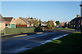
1
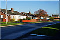
Bungalows on Baileywood Lane
Holme on Spalding Moor.
Image: © Ian S
Taken: 7 Nov 2013
0.03 miles
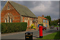

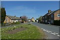
4
Chestnut Drive off Bailey Wood Lane
Holme on Spalding Moor.
Image: © Ian S
Taken: 7 Nov 2013
0.07 miles
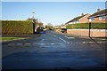
7
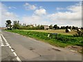
Baileywood Lane at its junction with Sands Lane
Image: © Martin Dawes
Taken: 16 Sep 2015
0.10 miles
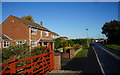
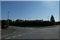
8
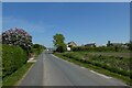
Baileywood Lane
Looking along Baileywood Lane in Holme-on-Spalding-Moor.
Image: © DS Pugh
Taken: 30 Apr 2022
0.10 miles
9
Runner End
Looking along Runner End from the junction with Baileywood Lane.
Image: © DS Pugh
Taken: 30 Apr 2022
0.10 miles
10
Cherry Drive
Looking from Sand Lane onto Cherry Drive. The house in view has a large number of amateur radio aerials.
Image: © DS Pugh
Taken: 30 Apr 2022
0.11 miles