IMAGES TAKEN NEAR TO
Drain Lane, YORK, YO43 4DQ
Introduction
This page details the photographs taken nearby to Drain Lane, YO43 4DQ by members of the Geograph project.
The Geograph project started in 2005 with the aim of publishing, organising and preserving representative images for every square kilometre of Great Britain, Ireland and the Isle of Man.

There are currently over 7.5m images from over14,400 individuals and you can help contribute to the project by visiting https://www.geograph.org.uk
Image Map (Loading...)


Getting Data...Please wait
Leaflet Map data © OpenStreetMap
Images are licensed for reuse under creativecommons.org/licenses/by-sa/2.0
Notes
- Clicking on the map will re-center to the selected point.
- The higher the marker number, the further away the image location is from the centre of the postcode.
Image Listing (17 Images Found)
Images are licensed for reuse under creativecommons.org/licenses/by-sa/2.0
Image
Details
Distance
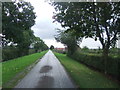
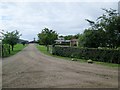
1

Road passing Pond View
Drain Lane passing a group of houses as it heads towards the junction with the A614 Howden Road.
Image: © DS Pugh
Taken: 9 Mar 2025
0.02 miles

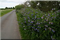
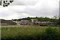
3
Rascal Wood: sign on Drain Lane
Area to the north is called Rascal Moor.
Image: © Chris
Taken: 6 Jun 2015
0.03 miles
7
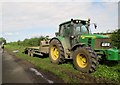
Tractor and low loader on Drain Lane
A digger was working in the field
Image: © Martin Dawes
Taken: 16 Sep 2015
0.11 miles