IMAGES TAKEN NEAR TO
Market Weighton Road, YORK, YO43 4AG
Introduction
This page details the photographs taken nearby to Market Weighton Road, YO43 4AG by members of the Geograph project.
The Geograph project started in 2005 with the aim of publishing, organising and preserving representative images for every square kilometre of Great Britain, Ireland and the Isle of Man.

There are currently over 7.5m images from over14,400 individuals and you can help contribute to the project by visiting https://www.geograph.org.uk
Image Map
Images are licensed for reuse under creativecommons.org/licenses/by-sa/2.0
Notes
- Clicking on the map will re-center to the selected point.
- The higher the marker number, the further away the image location is from the centre of the postcode.
Image Listing (24 Images Found)
Images are licensed for reuse under creativecommons.org/licenses/by-sa/2.0
Image
Details
Distance
1

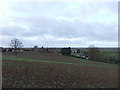
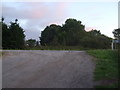
Sunset over fields north of Holme on Spalding Moor
Image: © Glyn Drury
Taken: 14 Sep 2009
0.06 miles
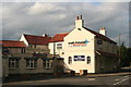
4
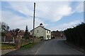
Former public house now business premises
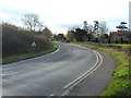
On a tight corner on the A164
Image: © Martin Dawes
Taken: 10 May 2017
0.12 miles
6
NEW
Daffodils along Old Road
Old Road in Holme on Spalding Moor.
Image: © DS Pugh
Taken: 9 Mar 2025
0.12 miles
8
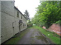
The shortest way to the church
The church at Holme upon Spalding Moor stands o a hill a little out of the village. This is the shortest route there from the village if you are on foot but I suspect that most people go by car and take a longer route.
Image: © Jonathan Thacker
Taken: 9 May 2014
0.12 miles
10
Guns and music based at a former pub in Holme on Spalding Moor
Image: © Chris
Taken: 6 Jun 2015
0.13 miles