IMAGES TAKEN NEAR TO
York Road, YORK, YO41 5LG
Introduction
This page details the photographs taken nearby to York Road, YO41 5LG by members of the Geograph project.
The Geograph project started in 2005 with the aim of publishing, organising and preserving representative images for every square kilometre of Great Britain, Ireland and the Isle of Man.

There are currently over 7.5m images from over14,400 individuals and you can help contribute to the project by visiting https://www.geograph.org.uk
Image Map (Loading...)


Getting Data...Please wait
Leaflet Map data © OpenStreetMap
Images are licensed for reuse under creativecommons.org/licenses/by-sa/2.0
Notes
- Clicking on the map will re-center to the selected point.
- The higher the marker number, the further away the image location is from the centre of the postcode.
Image Listing (8 Images Found)
Images are licensed for reuse under creativecommons.org/licenses/by-sa/2.0
Image
Details
Distance
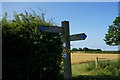
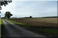
3
Junction of bridleways
To the left leads towards Stamford Bridge and to the right towards Kexby.
Image: © DS Pugh
Taken: 16 Oct 2022
0.16 miles
5
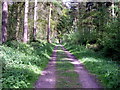
Millfield and Scoreby Wood
From the junction of the bridleways.
Image: © DS Pugh
Taken: 26 Apr 2006
0.20 miles
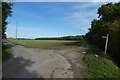
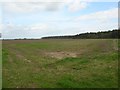
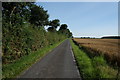
6
Fields south of South Farm
Looking along a bridleway north of the A1079.
Image: © DS Pugh
Taken: 16 Oct 2022
0.20 miles
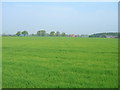
8
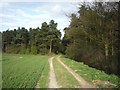
Approaching Millfield Wood
This bridleway runs from the Scoreby estate through to Kexby and the River Derwent.
Image: © DS Pugh
Taken: 22 Apr 2010
0.23 miles