IMAGES TAKEN NEAR TO
Kirbyunderdale, YORK, YO41 1QX
Introduction
This page details the photographs taken nearby to YO41 1QX by members of the Geograph project.
The Geograph project started in 2005 with the aim of publishing, organising and preserving representative images for every square kilometre of Great Britain, Ireland and the Isle of Man.

There are currently over 7.5m images from over14,400 individuals and you can help contribute to the project by visiting https://www.geograph.org.uk
Image Map (Loading...)


Getting Data...Please wait
Leaflet Map data © OpenStreetMap
Images are licensed for reuse under creativecommons.org/licenses/by-sa/2.0
Notes
- Clicking on the map will re-center to the selected point.
- The higher the marker number, the further away the image location is from the centre of the postcode.
Image Listing (12 Images Found)
Images are licensed for reuse under creativecommons.org/licenses/by-sa/2.0
Image
Details
Distance
4
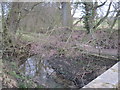
Salamanca Beck
Further upstream it is Waterloo Beck so we have a military theme here
Image: © Martin Dawes
Taken: 15 Jan 2012
0.17 miles

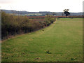
6
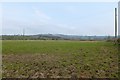
Farmland off Bugthorpe Lane
Looking towards the Wolds rising up in the distance.
Image: © DS Pugh
Taken: 20 Apr 2014
0.20 miles
7
Footpath off Bugthorpe Lane
A fingerpost indicates the footpath.
Image: © DS Pugh
Taken: 20 Apr 2014
0.21 miles
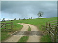
8
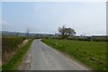
Road to Bugthorpe
Looking along Bugthorpe Lane between Bugthorpe and Kirby Underdale.
Image: © DS Pugh
Taken: 20 Jun 2020
0.22 miles
9
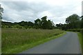
Along Bugthorpe Lane
Looking along Bugthorpe Lane leading towards Kirby Underdale.
Image: © DS Pugh
Taken: 20 Jun 2020
0.22 miles
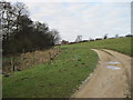
10
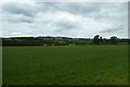
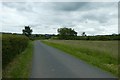
Fields beside Bugthorpe Lane
Looking across fields between Bugthorpe and Kirby Underdale.
Image: © DS Pugh
Taken: 20 Jun 2020
0.23 miles