IMAGES TAKEN NEAR TO
Scrayingham, YORK, YO41 1JG
Introduction
This page details the photographs taken nearby to YO41 1JG by members of the Geograph project.
The Geograph project started in 2005 with the aim of publishing, organising and preserving representative images for every square kilometre of Great Britain, Ireland and the Isle of Man.

There are currently over 7.5m images from over14,400 individuals and you can help contribute to the project by visiting https://www.geograph.org.uk
Image Map (Loading...)


Getting Data...Please wait
Leaflet Map data © OpenStreetMap
Images are licensed for reuse under creativecommons.org/licenses/by-sa/2.0
Notes
- Clicking on the map will re-center to the selected point.
- The higher the marker number, the further away the image location is from the centre of the postcode.
Image Listing (8 Images Found)
Images are licensed for reuse under creativecommons.org/licenses/by-sa/2.0
Image
Details
Distance
1
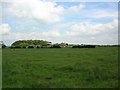
Wheathills Farm
Between Westow & Buttercrambe.
Image: © DS Pugh
Taken: 20 Jun 2006
0.10 miles

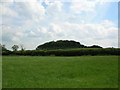
4

Track to Wheathills
A farm entrance beside Lowfield Lane.
Image: © DS Pugh
Taken: 23 Sep 2023
0.17 miles
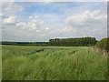
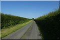
7

Farm lane and bridleway at Middle Gates
The lane is heading for Scrayingham Hall whilst the bridleway continues to Leppington.
Image: © Gordon Hatton
Taken: 17 Aug 2020
0.24 miles
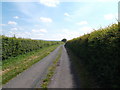
8
Driveway to Scrayingham Grange
Looking along a bridleway to Leppington.
Image: © DS Pugh
Taken: 23 Jun 2020
0.24 miles