IMAGES TAKEN NEAR TO
Towthorpe, YORK, YO32 9SS
Introduction
This page details the photographs taken nearby to YO32 9SS by members of the Geograph project.
The Geograph project started in 2005 with the aim of publishing, organising and preserving representative images for every square kilometre of Great Britain, Ireland and the Isle of Man.

There are currently over 7.5m images from over14,400 individuals and you can help contribute to the project by visiting https://www.geograph.org.uk
Image Map
Images are licensed for reuse under creativecommons.org/licenses/by-sa/2.0
Notes
- Clicking on the map will re-center to the selected point.
- The higher the marker number, the further away the image location is from the centre of the postcode.
Image Listing (14 Images Found)
Images are licensed for reuse under creativecommons.org/licenses/by-sa/2.0
Image
Details
Distance
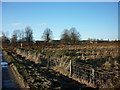
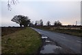
3
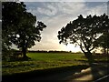
Fields beside Towthorpe Moor Lane
Looking across farmland in the setting sun.
Image: © DS Pugh
Taken: 20 Oct 2020
0.14 miles
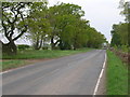
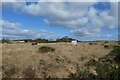
6
Looking over Towthorpe Common
Taken From Towthorpe Lane
Image: © Ian S
Taken: 8 Jan 2011
0.14 miles
7
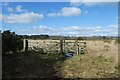
Path and gates on Towthorpe Common
This path runs across part of the military training area.
Image: © DS Pugh
Taken: 6 Mar 2022
0.15 miles
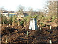
8
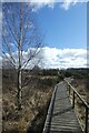
Boardwalk and birch tree
Looking along a path on Towthorpe Common.
Image: © DS Pugh
Taken: 6 Mar 2022
0.17 miles
9
Looking along Towthorpe Moor Lane
The southern boundary of Strensall barracks.
Image: © DS Pugh
Taken: 5 Jan 2014
0.18 miles
10
MoD warning signs on Strensall Common
Looking across part of the common near the rifle ranges.
Image: © DS Pugh
Taken: 6 Mar 2022
0.19 miles