IMAGES TAKEN NEAR TO
Church Lane, YORK, YO32 9RE
Introduction
This page details the photographs taken nearby to Church Lane, YO32 9RE by members of the Geograph project.
The Geograph project started in 2005 with the aim of publishing, organising and preserving representative images for every square kilometre of Great Britain, Ireland and the Isle of Man.

There are currently over 7.5m images from over14,400 individuals and you can help contribute to the project by visiting https://www.geograph.org.uk
Image Map
Images are licensed for reuse under creativecommons.org/licenses/by-sa/2.0
Notes
- Clicking on the map will re-center to the selected point.
- The higher the marker number, the further away the image location is from the centre of the postcode.
Image Listing (87 Images Found)
Images are licensed for reuse under creativecommons.org/licenses/by-sa/2.0
Image
Details
Distance
1
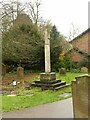
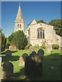
Cross in the churchyard, Huntington All Saints
Whether any parts of the cross are really old is unclear; the cross head is inscribed in commemoration of the centenary of the rebuilding in 1874.
Image: © Alan Murray-Rust
Taken: 4 Dec 2022
0.02 miles
3
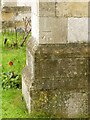
Bench mark, All Saints' Church, Huntington
See https://www.geograph.org.uk/photo/7360955 for location
Image: © Alan Murray-Rust
Taken: 4 Dec 2022
0.03 miles
4
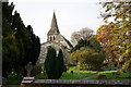
All Saints Church, Huntington
Set in the countryside between Huntington and New Earswick. It is on Church Lane, off the Old Village in Huntington. There has been a church on this site for the last 900 years. The exact date of the first church is unknown but a church was in existence in late Saxon times. A second church was built in the 12th or 13th Century and this was believed to have been reconstructed in the 15th century. Parts of the Norman building remain in the church today.
Image: © Paul Harrop
Taken: 9 Aug 2016
0.03 miles
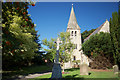
5
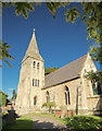
Church of All Saints, Huntington
The tower and spire; built 1874 in Geometric Decorated style. Listed Grade II*
Image: © Alan Murray-Rust
Taken: 4 Dec 2022
0.03 miles
6
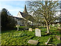
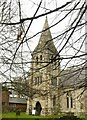
Church of All Saints, Huntington
View from the south east showing the nave and the tower and spire, built 1874, Listed Grade II*.
There is a benchmark https://www.geograph.org.uk/photo/7360953 on the near corner buttress of the nave.
Image: © Alan Murray-Rust
Taken: 4 Dec 2022
0.03 miles
7
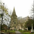
Church of All Saints, Huntington
View from the east, showing the 15th century chancel with 3-light Perpendicular east window.
The path is a public right of way running through to Haxby Road.
Image: © Alan Murray-Rust
Taken: 4 Dec 2022
0.03 miles
8
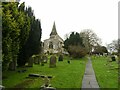
Graveyard and church, Huntington
Set in the countryside between Huntington and New Earswick. All Saints Church is on Church Lane, off the Old Village in Huntington. There has been a church on this site for the last 900 years. The exact date of the first one is unknown but a church was in existence in late Saxon times. A second church was built in the 12th or 13th Century and this was believed to have been reconstructed in the 15th century. Parts of the Norman building remain in the church today.
Image: © Paul Harrop
Taken: 9 Aug 2016
0.03 miles
9
Huntington Church from the east
Set in the countryside between Huntington and New Earswick. All Saints Church is on Church Lane, off the Old Village in Huntington. There has been a church on this site for the last 900 years. The exact date of the first one is unknown but a church was in existence in late Saxon times. A second church was built in the 12th or 13th Century and this was believed to have been reconstructed in the 15th century. Parts of the Norman building remain in the church today.
Image: © Paul Harrop
Taken: 9 Aug 2016
0.03 miles