IMAGES TAKEN NEAR TO
Flaxton Road, YORK, YO32 5XJ
Introduction
This page details the photographs taken nearby to Flaxton Road, YO32 5XJ by members of the Geograph project.
The Geograph project started in 2005 with the aim of publishing, organising and preserving representative images for every square kilometre of Great Britain, Ireland and the Isle of Man.

There are currently over 7.5m images from over14,400 individuals and you can help contribute to the project by visiting https://www.geograph.org.uk
Image Map
Images are licensed for reuse under creativecommons.org/licenses/by-sa/2.0
Notes
- Clicking on the map will re-center to the selected point.
- The higher the marker number, the further away the image location is from the centre of the postcode.
Image Listing (8 Images Found)
Images are licensed for reuse under creativecommons.org/licenses/by-sa/2.0
Image
Details
Distance
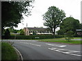
1

Clubhouse, York Golf Club
The view from the windows is southwards, across Lords Moor Lane to the course.
Image: © Christine Johnstone
Taken: 18 Dec 2015
0.05 miles
3

Lords Moor Lane passing through York Golf Club
The clubhouse is on the left / north, the course on the right / south.
Image: © Christine Johnstone
Taken: 18 Dec 2015
0.05 miles
4

Bench under the oak trees, outside York Golf Club
Where Flaxton Road meets Lords Moor Lane.
Image: © Christine Johnstone
Taken: 18 Dec 2015
0.07 miles
5

Oak trees alongside Lords Moor Lane
A mild, if wet, mid-December.
Image: © Christine Johnstone
Taken: 18 Dec 2015
0.07 miles
6

Entrance to the York Golf Club
South-east of Strensall village, off Lords Moor Lane..
Image: © Christine Johnstone
Taken: 18 Dec 2015
0.08 miles
7

Woodland path heading east to Lords Moor Lane
According to the parish council, for the use of pedestrians and powered wheelchairs only.
Image: © Christine Johnstone
Taken: 18 Dec 2015
0.11 miles
8
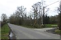
Passing the golf course
Looking along Lords Moor Lane near Strensall.
Image: © DS Pugh
Taken: 14 Apr 2018
0.16 miles