IMAGES TAKEN NEAR TO
Alexandra Road, YORK, YO32 5SE
Introduction
This page details the photographs taken nearby to Alexandra Road, YO32 5SE by members of the Geograph project.
The Geograph project started in 2005 with the aim of publishing, organising and preserving representative images for every square kilometre of Great Britain, Ireland and the Isle of Man.

There are currently over 7.5m images from over14,400 individuals and you can help contribute to the project by visiting https://www.geograph.org.uk
Image Map
Images are licensed for reuse under creativecommons.org/licenses/by-sa/2.0
Notes
- Clicking on the map will re-center to the selected point.
- The higher the marker number, the further away the image location is from the centre of the postcode.
Image Listing (12 Images Found)
Images are licensed for reuse under creativecommons.org/licenses/by-sa/2.0
Image
Details
Distance

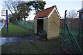
4
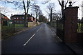
Entrance to Queen Elizabeth Barracks, Strensall
Image: © Ian S
Taken: 17 Jan 2018
0.12 miles
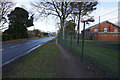
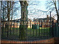
5

Cheshire Avenue, Queen Elizabeth Barracks, Strensall
Image: © Ian S
Taken: 8 Jan 2011
0.12 miles
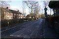
7
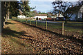
Strensall Park, Strensall
Former army housing at Strensall Camp.
Image: © Ian S
Taken: 17 Jan 2018
0.15 miles
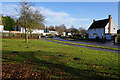
8
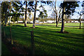
Strensall Park, Strensall
Former army housing.
Image: © Ian S
Taken: 17 Jan 2018
0.19 miles