IMAGES TAKEN NEAR TO
Conifer Close, YORK, YO32 4TT
Introduction
This page details the photographs taken nearby to Conifer Close, YO32 4TT by members of the Geograph project.
The Geograph project started in 2005 with the aim of publishing, organising and preserving representative images for every square kilometre of Great Britain, Ireland and the Isle of Man.

There are currently over 7.5m images from over14,400 individuals and you can help contribute to the project by visiting https://www.geograph.org.uk
Image Map
Images are licensed for reuse under creativecommons.org/licenses/by-sa/2.0
Notes
- Clicking on the map will re-center to the selected point.
- The higher the marker number, the further away the image location is from the centre of the postcode.
Image Listing (96 Images Found)
Images are licensed for reuse under creativecommons.org/licenses/by-sa/2.0
Image
Details
Distance
1

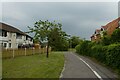
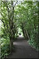
Cycle path in New Earswick
Leading through to Alder Way.
Image: © DS Pugh
Taken: 5 Jan 2014
0.03 miles
2
Cycle path in New Earswick
Looking along a path connecting Alder Way to Magnolia Grove.
Image: © DS Pugh
Taken: 3 Jun 2021
0.03 miles
4
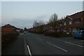
Alder Way
Looking along a street in New Earswick.
Image: © DS Pugh
Taken: 6 Mar 2021
0.07 miles
5
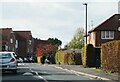
Alder Way, New Earswick
Suburban street on the southern fringe of New Earswick.
Image: © Gordon Hatton
Taken: 22 Oct 2022
0.09 miles
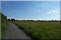
6
Path south of New Earswick
Looking along the former railway line.
Image: © DS Pugh
Taken: 3 Jun 2021
0.10 miles
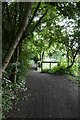
7
Path to Nestle
Looking along a path from New Earswick to Nestle North Gate.
Image: © DS Pugh
Taken: 14 Jun 2020
0.11 miles
8
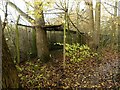
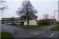
New Earswick Nature Reserve ? Heligoland bird trap
The reserve was formed on the site of the brickworks created to provide bricks for the early stages of development of New Earswick village from around 1900. It closed in 1933 and the area became wild.
In 1973 it was established as a Designated Educational Nature Reserve, since 2019 leased to the group formed some years previously to manage the reserve. The pool resulted from the extraction of clay for the bricks and is naturally filled from groundwater. The only other physical remains are a section of brick paving, possibly the base of a beehive kiln, and the concrete base of the windpump used to keep the claypit free of water. Due to vandalism, the reserve has had to be securely enclosed and is only open to keyholders and on limited open days.
Image: © Alan Murray-Rust
Taken: 4 Dec 2022
0.11 miles
9
Path on the former railway
Looking along a path running along the edge of New Earswick.
Image: © DS Pugh
Taken: 3 Jun 2021
0.11 miles
10
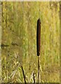
Reedmace in New Earswick Nature Reserve
Image: © Alan Murray-Rust
Taken: 4 Dec 2022
0.12 miles