IMAGES TAKEN NEAR TO
Woodland Place, YORK, YO32 4TR
Introduction
This page details the photographs taken nearby to Woodland Place, YO32 4TR by members of the Geograph project.
The Geograph project started in 2005 with the aim of publishing, organising and preserving representative images for every square kilometre of Great Britain, Ireland and the Isle of Man.

There are currently over 7.5m images from over14,400 individuals and you can help contribute to the project by visiting https://www.geograph.org.uk
Image Map
Images are licensed for reuse under creativecommons.org/licenses/by-sa/2.0
Notes
- Clicking on the map will re-center to the selected point.
- The higher the marker number, the further away the image location is from the centre of the postcode.
Image Listing (69 Images Found)
Images are licensed for reuse under creativecommons.org/licenses/by-sa/2.0
Image
Details
Distance
1
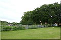
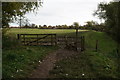
Allotments in New Earswick
Looking towards allotments beside Willow Bank.
Image: © DS Pugh
Taken: 23 Jun 2019
0.06 miles
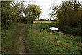
3
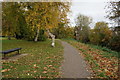
River Foss at New Earswick
Looking towards Huntingdon. The footpath is path of the Foss Walk long distance path
Image: © Alan Murray-Rust
Taken: 4 Dec 2022
0.07 miles
4
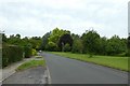
Willow Bank
Looking along Willow Bank in New Earswick.
Image: © DS Pugh
Taken: 23 Jun 2019
0.07 miles
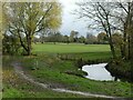
5
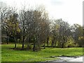
Willow Bank, New Earswick
Recently (early 21st century) planted trees.
Image: © Alan Murray-Rust
Taken: 4 Dec 2022
0.07 miles
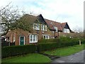
6
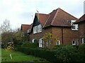
New Earswick ? 98-104 (even) Chestnut Grove
Image: © Alan Murray-Rust
Taken: 4 Dec 2022
0.08 miles
9
New Earswick – 77-83 (odd) Chestnut Grove
Image: © Alan Murray-Rust
Taken: 4 Dec 2022
0.09 miles
