IMAGES TAKEN NEAR TO
Calf Close, YORK, YO32 3NT
Introduction
This page details the photographs taken nearby to Calf Close, YO32 3NT by members of the Geograph project.
The Geograph project started in 2005 with the aim of publishing, organising and preserving representative images for every square kilometre of Great Britain, Ireland and the Isle of Man.

There are currently over 7.5m images from over14,400 individuals and you can help contribute to the project by visiting https://www.geograph.org.uk
Image Map
Images are licensed for reuse under creativecommons.org/licenses/by-sa/2.0
Notes
- Clicking on the map will re-center to the selected point.
- The higher the marker number, the further away the image location is from the centre of the postcode.
Image Listing (43 Images Found)
Images are licensed for reuse under creativecommons.org/licenses/by-sa/2.0
Image
Details
Distance
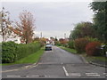
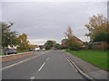
1
Calf Close
Looking along Calf Close in Haxby where the road splits.
Image: © DS Pugh
Taken: 23 Jun 2019
0.04 miles
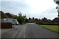
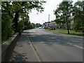
2
Along Calf Close
Looking along Calf Close in Haxby.
Image: © DS Pugh
Taken: 23 Jun 2019
0.06 miles
3
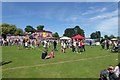
Haxby Carnival
Looking across Ethel Ward Memorial Playing Fields during Haxby's annual carnival.
Image: © DS Pugh
Taken: 8 Jul 2017
0.10 miles
4
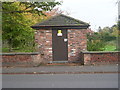
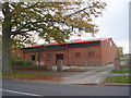
Electricity Substation - York Road
Image: © Betty Longbottom
Taken: 29 Oct 2011
0.13 miles
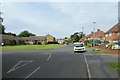
7

Ethel Ward Memorial Playing Field - York Road
Image: © Betty Longbottom
Taken: 29 Oct 2011
0.14 miles
9
2nd Haxby & Wigginton Scout Group - York Road
Image: © Betty Longbottom
Taken: 29 Oct 2011
0.17 miles