IMAGES TAKEN NEAR TO
Stoop Close, YORK, YO32 2WX
Introduction
This page details the photographs taken nearby to Stoop Close, YO32 2WX by members of the Geograph project.
The Geograph project started in 2005 with the aim of publishing, organising and preserving representative images for every square kilometre of Great Britain, Ireland and the Isle of Man.

There are currently over 7.5m images from over14,400 individuals and you can help contribute to the project by visiting https://www.geograph.org.uk
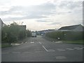
Image Map
Images are licensed for reuse under creativecommons.org/licenses/by-sa/2.0
Notes
- Clicking on the map will re-center to the selected point.
- The higher the marker number, the further away the image location is from the centre of the postcode.
Image Listing (43 Images Found)
Images are licensed for reuse under creativecommons.org/licenses/by-sa/2.0
Image
Details
Distance
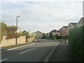
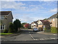
3
Green Dike
Looking along Green Dike in Haxby from the junction with Lund Close.
Image: © DS Pugh
Taken: 5 Nov 2022
0.04 miles
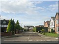
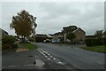
9

Eastfield Avenue - viewed from Wheatfield Lane
Image: © Betty Longbottom
Taken: 29 Oct 2011
0.07 miles
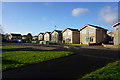
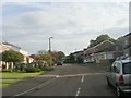
10
Woodlands Avenue - Wheatfield Lane
Image: © Betty Longbottom
Taken: 29 Oct 2011
0.08 miles