IMAGES TAKEN NEAR TO
Highthorn Road, YORK, YO31 9HF
Introduction
This page details the photographs taken nearby to Highthorn Road, YO31 9HF by members of the Geograph project.
The Geograph project started in 2005 with the aim of publishing, organising and preserving representative images for every square kilometre of Great Britain, Ireland and the Isle of Man.

There are currently over 7.5m images from over14,400 individuals and you can help contribute to the project by visiting https://www.geograph.org.uk
Image Map
Images are licensed for reuse under creativecommons.org/licenses/by-sa/2.0
Notes
- Clicking on the map will re-center to the selected point.
- The higher the marker number, the further away the image location is from the centre of the postcode.
Image Listing (26 Images Found)
Images are licensed for reuse under creativecommons.org/licenses/by-sa/2.0
Image
Details
Distance
1
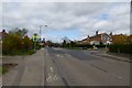
Huntington Road
Huntington Road at its junction with Highthorn Road.
Image: © DS Pugh
Taken: 13 Apr 2014
0.11 miles
2
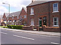
The Old And The New
Traditional terraced housing meets new a new 'link' housing development in New Earswick. I know which I prefer.
Image: © Weston Beggard
Taken: 29 Apr 2006
0.12 miles
3

The Yearsley Grove
A large, family-centred pub in New Earswick.
Image: © Weston Beggard
Taken: 29 Apr 2006
0.12 miles
4

Meadowfields Drive
A typical suburban scene to the North of York.
Image: © Weston Beggard
Taken: 29 Apr 2006
0.12 miles
5
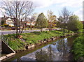
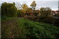
River Foss
The River Foss runs parallel to Huntington Road for a short distance.
Image: © Weston Beggard
Taken: 29 Apr 2006
0.12 miles
6
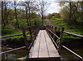
Footbridge
Footbridge over the River Foss, leading onto public land from Huntington Road.
Image: © Weston Beggard
Taken: 29 Apr 2006
0.12 miles
7
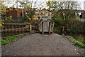
Footbridge over the River Foss
At Huntington Road, York.
Image: © Ian S
Taken: 16 Nov 2013
0.12 miles
8
Footbridge over the River Foss
At Huntington Road, York.
Image: © Ian S
Taken: 16 Nov 2013
0.13 miles
9
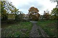
Footbridge over the River Foss
The footbridge comes out on Huntington Road near Highthorn Road.
Image: © DS Pugh
Taken: 25 Oct 2020
0.13 miles
10
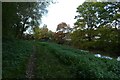
River Foss and bridge
The bridge connects the path to Huntington Road.
Image: © DS Pugh
Taken: 25 Oct 2020
0.14 miles