IMAGES TAKEN NEAR TO
Park Crescent, YORK, YO31 7NU
Introduction
This page details the photographs taken nearby to Park Crescent, YO31 7NU by members of the Geograph project.
The Geograph project started in 2005 with the aim of publishing, organising and preserving representative images for every square kilometre of Great Britain, Ireland and the Isle of Man.

There are currently over 7.5m images from over14,400 individuals and you can help contribute to the project by visiting https://www.geograph.org.uk
Image Map
Images are licensed for reuse under creativecommons.org/licenses/by-sa/2.0
Notes
- Clicking on the map will re-center to the selected point.
- The higher the marker number, the further away the image location is from the centre of the postcode.
Image Listing (311 Images Found)
Images are licensed for reuse under creativecommons.org/licenses/by-sa/2.0
Image
Details
Distance
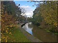
1
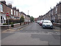
Park Crescent - Bowling Green Lane
Image: © Betty Longbottom
Taken: 24 May 2017
0.02 miles
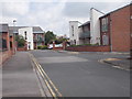
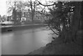
5
Foss from Heworth Green
Looking upstream along the River Foss.
Image: © DS Pugh
Taken: 25 Oct 2020
0.06 miles

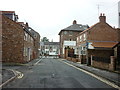
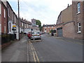
8

Funeral directors flying flags
Looking towards J Rymer on Penley's Grove Street.
Image: © DS Pugh
Taken: 14 Jun 2022
0.06 miles
9
The River Foss seen from Monkbridge Landing, York
Image: © habiloid
Taken: 1 Mar 2024
0.06 miles
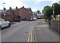
10
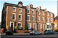
Terraced houses, Monkgate
A three storey terrace of the 1830's still showing the good proportions of the Georgian period. Only the later bay window at number 51 spoils the overall effect.
Image: © Gordon Hatton
Taken: 6 Jan 2009
0.06 miles