IMAGES TAKEN NEAR TO
Algarth Road, YORK, YO31 1HA
Introduction
This page details the photographs taken nearby to Algarth Road, YO31 1HA by members of the Geograph project.
The Geograph project started in 2005 with the aim of publishing, organising and preserving representative images for every square kilometre of Great Britain, Ireland and the Isle of Man.

There are currently over 7.5m images from over14,400 individuals and you can help contribute to the project by visiting https://www.geograph.org.uk
Image Map
Images are licensed for reuse under creativecommons.org/licenses/by-sa/2.0
Notes
- Clicking on the map will re-center to the selected point.
- The higher the marker number, the further away the image location is from the centre of the postcode.
Image Listing (54 Images Found)
Images are licensed for reuse under creativecommons.org/licenses/by-sa/2.0
Image
Details
Distance
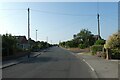
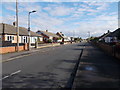
1
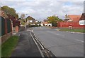
Algarth Road - viewed from Ash Close
Image: © Betty Longbottom
Taken: 17 Oct 2015
0.03 miles
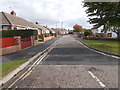
5
Along Ashley Park Drive
Looking towards the junction with Springfield Way.
Image: © DS Pugh
Taken: 22 Jul 2021
0.09 miles
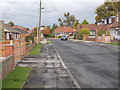
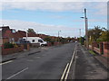
8

Applecroft Road - viewed from Ashley Park Road
Image: © Betty Longbottom
Taken: 17 Oct 2015
0.10 miles
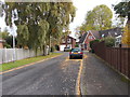
9
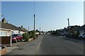
Ashley Park Road
Looking along Ashley Park Road near Springfield Way in Heworth.
Image: © DS Pugh
Taken: 22 Jul 2021
0.10 miles
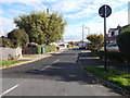
10
Springfield Way - Ashley Park Road
Image: © Betty Longbottom
Taken: 17 Oct 2015
0.11 miles