IMAGES TAKEN NEAR TO
Langdale Avenue, YORK, YO31 0LT
Introduction
This page details the photographs taken nearby to Langdale Avenue, YO31 0LT by members of the Geograph project.
The Geograph project started in 2005 with the aim of publishing, organising and preserving representative images for every square kilometre of Great Britain, Ireland and the Isle of Man.

There are currently over 7.5m images from over14,400 individuals and you can help contribute to the project by visiting https://www.geograph.org.uk
Image Map
Images are licensed for reuse under creativecommons.org/licenses/by-sa/2.0
Notes
- Clicking on the map will re-center to the selected point.
- The higher the marker number, the further away the image location is from the centre of the postcode.
Image Listing (50 Images Found)
Images are licensed for reuse under creativecommons.org/licenses/by-sa/2.0
Image
Details
Distance
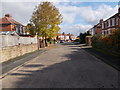
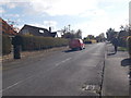
2
Burnholme Avenue
Looking along Burnholme Avenue near a snicket through to Bad Bargain Lane.
Image: © DS Pugh
Taken: 17 Jan 2021
0.06 miles
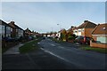
4

Thirlmere Drive - Burnholme Avenue
Image: © Betty Longbottom
Taken: 17 Oct 2015
0.08 miles
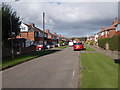
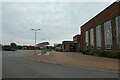
6

The Centre @ Burnholme
Recently constructed centre with a library and other facilities on the NE side of York.
Image: © Gordon Hatton
Taken: 14 Mar 2023
0.09 miles
7
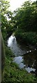
Tang Hall Beck
This beck flows through a busy residential area in Tang Hall, York
Image: © Stuart and Fiona Jackson
Taken: 8 Jul 2005
0.09 miles
8
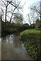
Tang Hall Beck
Looking downstream near Hemplands School.
Image: © DS Pugh
Taken: 17 Jan 2021
0.10 miles
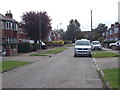
10
Burnholme Nursery
A path leads from here into Derwenthorpe.
Image: © DS Pugh
Taken: 16 Oct 2021
0.11 miles