
IMAGES TAKEN NEAR TO
Hetherton Street, YORK, YO30 7DX
Introduction
This page details the photographs taken nearby to Hetherton Street, YO30 7DX by members of the Geograph project.
The Geograph project started in 2005 with the aim of publishing, organising and preserving representative images for every square kilometre of Great Britain, Ireland and the Isle of Man.

There are currently over 7.5m images from over14,400 individuals and you can help contribute to the project by visiting https://www.geograph.org.uk
Image Map
Images are licensed for reuse under creativecommons.org/licenses/by-sa/2.0
Notes
- Clicking on the map will re-center to the selected point.
- The higher the marker number, the further away the image location is from the centre of the postcode.
Image Listing (1980 Images Found)
Images are licensed for reuse under creativecommons.org/licenses/by-sa/2.0
Image
Details
Distance
1
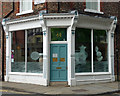
Detail of 64 Marygate, York
Victorian shopfront with decorative brackets.
Home to York Orthodontics at the time.
Image: © Stephen Richards
Taken: 14 May 2013
0.01 miles
3
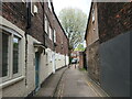
Posts on Marygate Lane, York
On the route of York's longest snicket, as mapped in 'A Walk around the Snickelways of York', by Mark W. Jones [2nd edition, 1984]. A snickelway is a narrow passageway or alley between walls, fences or buildings.
Image: © Christine Johnstone
Taken: 16 May 2023
0.02 miles
4

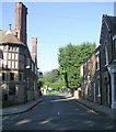
Bay Horse, Marygate, York
Jolly big pub, sort of neo-Tudor crossed with Arts and Crafts. Tile hanging, half-timbering and massive stacks. By Penty & Penty, 1894. Grade II listed.
Image: © Stephen Richards
Taken: 14 May 2013
0.02 miles
5
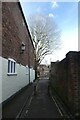
Marygate Lane
Looking along Marygate Lane which runs between Marygate and Frederic Street.
Image: © DS Pugh
Taken: 19 Mar 2023
0.02 miles
6
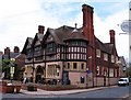
The Bay Horse, Marygate
Large town pub dating from 1894 and built in a vaguely mock Tudor style.
Image: © Gordon Hatton
Taken: 28 Apr 2010
0.02 miles
8
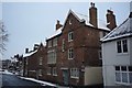
Marygate
Looking towards the River Ouse and the Bay Horse pub.
Image: © DS Pugh
Taken: 19 Jan 2013
0.03 miles
9
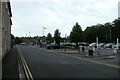
Frederic Street
Looking towards Marygate car park.
Image: © DS Pugh
Taken: 23 Aug 2023
0.03 miles
10
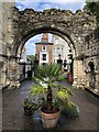
St Mary's Lodge Gatehouse
Remains of the C 12th gatehouse that formed the main entrance to St Mary's Abbey. The adjacent lodge was built in the C 15th.
Image: © David Robinson
Taken: 27 Sep 2021
0.03 miles